


KANSAS CITY, Mo. — Dozens of tornadoes were reported over the weekend through Tennessee, Kentucky, Mississippi and Alabama. The hardest area hit was Middle Tennessee, just outside of Nashville, where the National Weather Service estimates 13 tornadoes touched down.
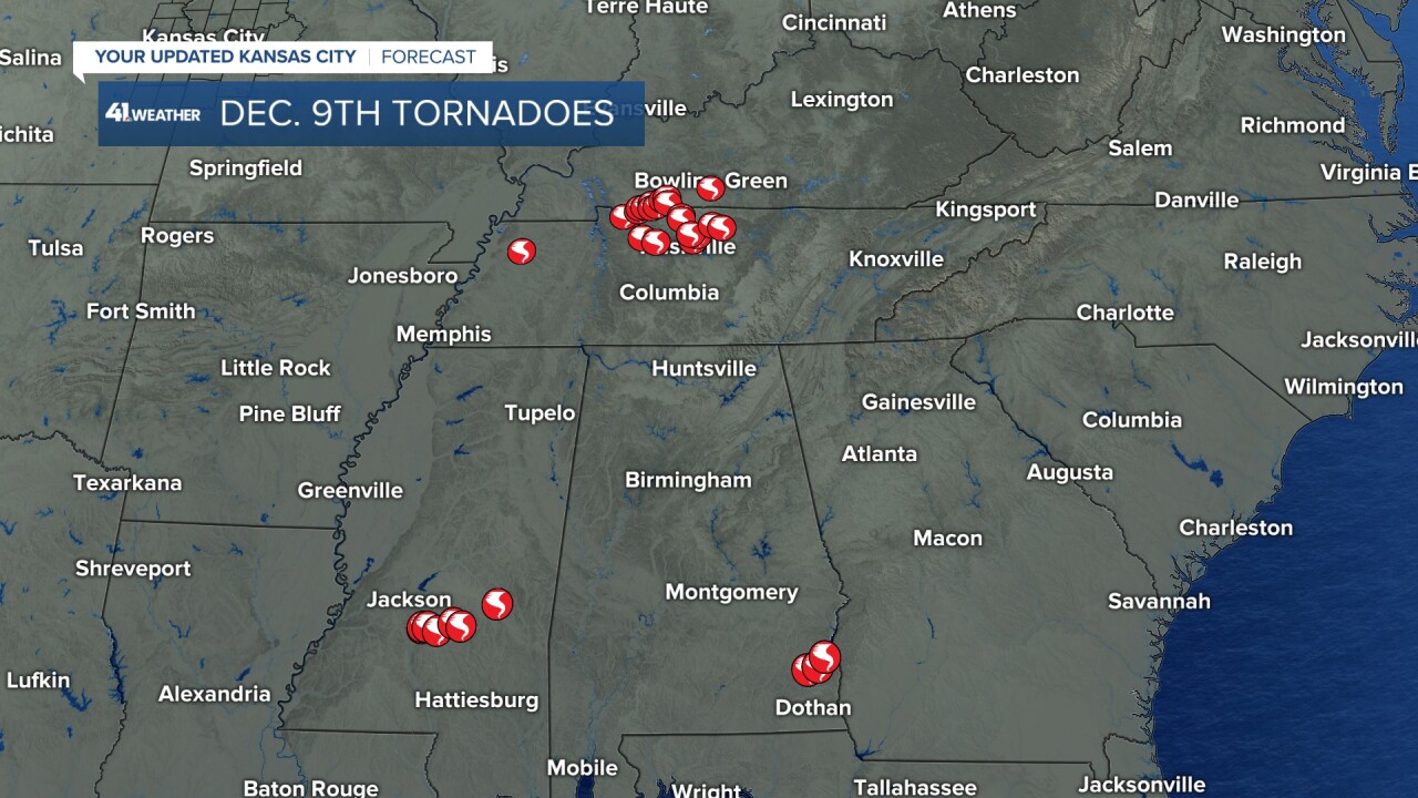
The National Weather Service in Nashville has been out surveying damage the last few days and our sister station WTVF in Nashville is following with the latest. The largest of the tornadoes so far is an EF-3 that touched down in Clarksville at 1:41 p.m. and produced 150 mph winds over across the width of 600 yards for an estimated 11-mile track.
Preliminary storm reports from US National Weather Service Nashville Tennessee indicate the following.
— Bree Sunshine Smith ☀️ (@NC5_BreeSmith) December 10, 2023
1. Long track tornado went through Clarksville with 150mph wind (EF3) & continued into Todd Co producing EF2 damage, likely connecting to damage near Bowling Green also.
1/2 pic.twitter.com/uhWkMuzypI
But how rare are cool season tornadoes? The cool season is defined as November through February and tornadoes during this time do favor the Gulf Coast, with 68% of all December through February tornadoes in the United States.
But cool season tornadoes are not limited to just the Gulf Coast. If we look at tornado climatology (1998-2022) for the month of December you can see on average Missouri sees two tornadoes as well as Tennessee.

On average across the United States we average 43 tornadoes through the month of December and so far this year we have a preliminary count of 32.
December Tornadoes
- 2022: 58
- 2021: 248
- 2020: 27
- 2019: 60
- 2018: 55
- 2017: 14
- 2016: 19
- 2015: 87
- 2014: 20
- 2013: 20
It should be noted 2021 has the highest number of tornadoes for the month of December in US history, this was the historic Dec. 10-11 outbreak with 70 tornadoes touching down, many deadly. 2021 was also a La Nina year and there is no secret that El Niño and La Niña influence tornado climatology.
During the top ten strongest La Niña events (2011, 1998, 1971, 2007, 1999, 1970, 1988, 2010, 1975, 1973), the total December tornado watch days favor Louisiana, Mississippi and Alabama. In Kansas City we tend to see roughly two watch days during a strong La Niña during December.

But that is not our set up this year, we are holding onto a Strong El Nino for the winter and that means an amplified jet through the southern United States.
During the top ten strongest El Niño events (2009, 1979, 2002, 1986, 1994, 1987, 1991, 1972, 1997, 1982) we tend to see more December watch days overall with the hot spot in a similar location. The difference here is there is a surge north for watch days along the Mississippi River.

This makes sense because our amplified strong track along the Gulf Coast will be tapping into moisture from the Gulf and lifting it further north. With the right storm set up we could be fueling more severe weather for those along the Mississippi Valley and along the Gulf Coast. In Kansas City, we tend to see roughly two watch days during the month of December. So the influence of La Niña vs El Niño doesn't really amp up to calm down severe weather concerns for us, at least during the month of December.
We are trending warm this winter, and climate change is a part of that warming. December is favored to be warmer than normal for many with active weather to persist across the South.
Give it a few days & it will feel like Spring! There is some serious heat building into Canada (as temps read cold, they are actually 20°+ above norm by Thu). The US outlook for Dec could hold more warmth across the Plains & right now is tracking wet from KC to the Gulf. @KSHB41 pic.twitter.com/AY0WNLUavn
— ☀️ Cassie Wilson (@CassieKSHB) December 4, 2023
As the climate continues to warm, the number of days where we are forecasting severe weather is projected to increase. And the cool season is no exception, a study by Climate Central proves that "Conditions favorable to supercells and tornadoes are expanding into historically less-active winter months."
—
