


KANSAS CITY, Mo. — We are living through a historic heat combination in Kansas City and it all started Saturday, Aug. 19.
The National Weather Service in Kansas City wants to emphasize this heat is not only historic, but possibly unprecedented and something we all need to take seriously. They say here are things people should do:
- Not work or do anything strenuous outside other then early in the day;
- Outside school activities should not be occurring unless very early in the morning/before school;
- Check on elderly neighbors and relatives or anyone else who may not have air conditioning; make sure they have air conditioning
But you might ask, hasn't Kansas City been hotter or what makes this heat so different? When it comes to just reading the mercury, yes, we have been hotter.
But most of the historic heat waves in Kansas City have one important thing in common — they happened during the dust bowl.
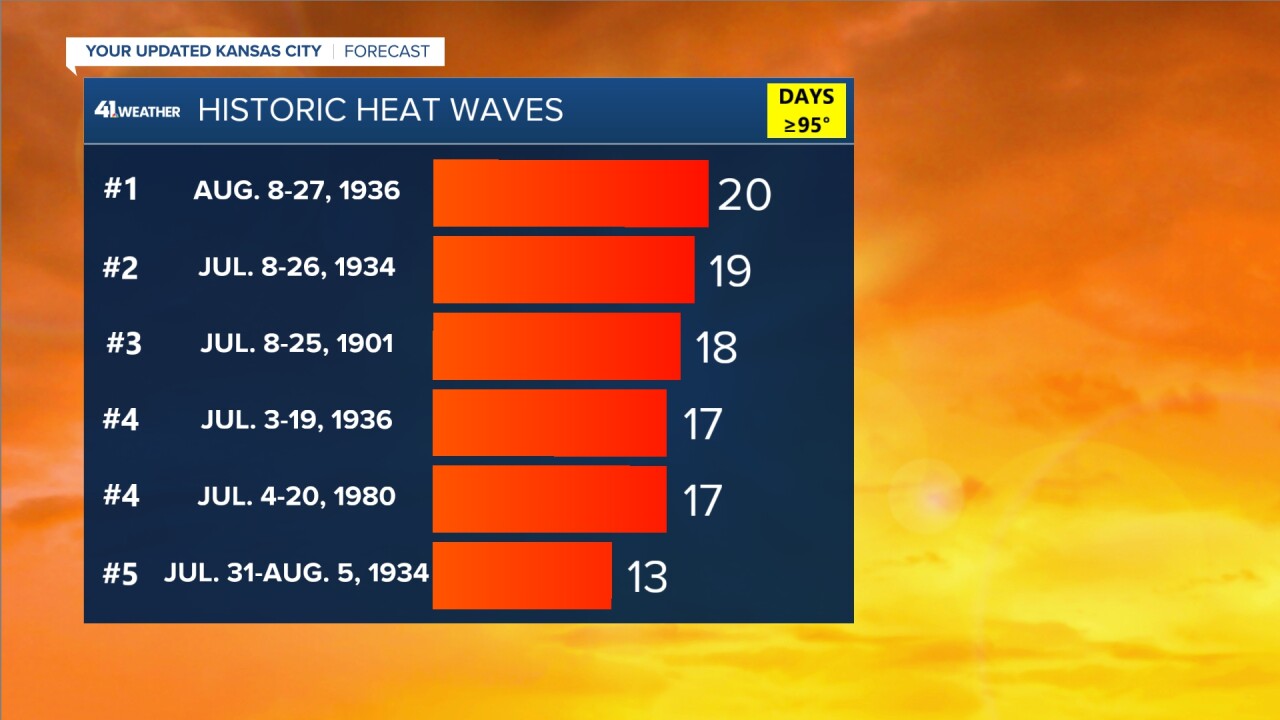
The dust bowl occurred in the mid 1930's and was a period of extreme drought across the Midwest. It is a well known dry period in our history and the feel of the heat then was just different.
While those heat waves lasted longer, they were not coupled with as much humidity as we are feeling now in 2023.

The hottest days this year and possibly ever in Kansas City were spent sweating it out by all Saturday and Sunday as the heat index jumped to over 120 degrees both days.
Which is why comparing this heat wave to any dust bowl era heat is like comparing apples to oranges. But what about our most recent heat wave? We can at least look at the most recent heat heat wave in the 21st century, something that has a similar baseline climate, for that we flash back to the summer of 2012.
The summer of 2012 was the last time we saw a prolonged heat event for five-plus days.
But even our most recent heat wave was built differently.
During the summer of 2012 we actually saw two heat waves — the first June 27 - July 7 and the second July 14 - 26. These heat waves lasted longer, were hotter, but had significantly lower humidity levels.
And when it comes to heat related illness, a lower humidity goes a long way.
For quick reference I pulled the 4 p.m. readings of temperature and humidity for both heat wave periods.

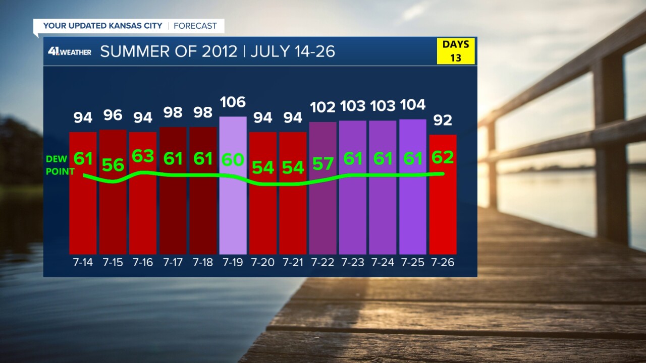
On July 22, 2012, is was 102 degrees, but the dew point was 57 degrees. This matters because that keeps the heat index at 102 degrees.
Dew points basically measure the amount of moisture in the air — the higher the dew point, the hotter it feels. Humid heat impacts our health.
When humidity is high our sweat cools less, our hearts pump faster and our kidneys work harder. Heat related illness can set in faster and hit harder overall.
This is why this heat wave is particularly more dangerous than anything we've witnessed in Kansas City history.
But in a warming world, juicy dew points will become our new normal.
According to a study by Climate Central, "as summers get hotter from the increase in greenhouse gases, they are also getting stickier. More evaporation occurs in a warming atmosphere, and on a world where water covers nearly three-quarters of the surface, it means an increase in water vapor in the air."

While we have been focusing on the Heat Index, the overnight warmth is sneaking closer and closer to record territory.
Nighttime temperatures are out pacing daytime temperatures increases and it comes with a cost; urban heat cores can't cool down, the heat stress window extends further and we see a jump in cooling costs and cooling needs.
While our daytime temperatures aren't quite at record territory, our overnight temperatures are. The next few days we will be close to breaking records.

Breaking our heat record Wednesday morning can directly be tied to climate change.
The Climate Shift Index (CSI) shows that our Wednesday morning low temperature has a climate shift index of 3. The CSI is a categorical scale with the categories defined by the ratio of how common (or likely) a temperature is in today's altered climate vs. how common it would be in a climate without human-caused climate change.
A CSI of 3 means that kind of temperature has been made three times more likely due to climate change.

Please take this heat seriously, be on the look out for heat related illness especially in vulnerable populations.
Everyone is at risk from the dangers of extreme heat, but these groups are more vulnerable than most. Ensure that your loved ones and neighbors are safe from the heat and remain #WeatherReady. https://t.co/Yq3bqbWehG pic.twitter.com/YP3wrQyzBD
— NWS Kansas City (@NWSKansasCity) July 27, 2023
