


KANSAS CITY, Mo. — Severe weather, including several tornado watches and warnings, moved through the Kansas City area on Tuesday afternoon.
As storm reports roll in, the region remains under a flood watch through Wednesday morning.
LINK | Latest KSHB 41 forecast
LINK | Latest KSHB 41 radar
—
8:33 p.m. | Kansas Gov. Laura Kelly issued a "verbal state of disaster emergency proclamation" Tuesday afternoon due to "heavy rainfall impacting portions of the state with the potential of flooding and flash flooding," per the governor's website.
The declaration paves the way for resources to provide state assistance.
7:49 p.m. | The tornado watch for Missouri's Henry and Pettis counties has been canceled, per the National Weather Service.
7:47 p.m. | Downed tree limbs in Independence narrowly missed a home. Catch Isabella Ledonne's report below.
7:06 p.m. | Henry and Pettis counties in Missouri remain under a tornado watch until 8 p.m.
The watch has been canceled for Carroll, Johnson, Sullivan, Linn, Lafayette and Saline counties in Missouri.
5:33 p.m. | Shortly after 5:30 p.m., Evergy reported over 7,200 customers out, BPU reported 39 affected and IPL showed 2,448 affected customers.
5:20 p.m. | Heavy rains mean flooding concerns in the Kansas City metro. KSHB 41's Abby Dodge reported on the situation at Indian Creek.
5:04 p.m. | The National Weather Service has issued a flash flood warning until 9 p.m. for counties south of the metro.
Kansas' Linn and Miami counties and Missouri's Bates and southwestern Cass counties are included.
Flash Flood Warning including Harrisonville MO, Paola KS and Osawatomie KS until 9:00 PM CDT pic.twitter.com/D8PeVjscm6
— NWS Kansas City (@NWSKansasCity) June 3, 2025
4:58 p.m. | KSHB 41 reporters Isabella Ledonne and Fernanda Silva went to Independence to survey the area's severe storm damage. You can watch their updates below.
4:32 p.m. | Several KSHB 41 viewers have submitted photos and videos of Tuesday's severe weather, including the entry below.
4:25 p.m. | Parts of the Kansas City area remain under a tornado watch until 8 p.m.
Johnson, Sullivan, Linn, Lafayette, Saline, Carroll, Henry and Pettis counties in Missouri are included in the watch.
The watch has been canceled for Livingston, Ray, Cass, Caldwell, Jackson and Bates counties in Missouri, as well as Kansas' Miami, Linn and Johnson counties.
4:15 p.m. | KSHB 41's Isabella Ledonne provided a second check-in from Kauffman Stadium. You can watch her report below.
4:11 p.m. | Just after 4 p.m., Evergy reported over 11,000 customers out, BPU reported 7 total outages and IPL showed 2,705 affected customers.
4:02 p.m. | KSHB 41 reporter Isabella Ledonne is checking out storm damage in Independence. She started around 3:15 p.m. outside Kauffman Stadium.
A couple of workers told her they saw the rain swirling outside.
"I heard the sirens, and that was enough for me," Jenni Anderson, Kauffman Stadium employee, told Ledonne.
3:30 p.m. | A severe thunderstorm warning until 4:15 p.m. includes northeastern Cass, northwestern Pettis, central Ray, southern Carroll, western Saline, Lafayette, southeastern Jackson and northern Johnson counties in Missouri.
Severe Thunderstorm Warning including Warrensburg MO, Pleasant Hill MO and Oak Grove MO until 4:15 PM CDT pic.twitter.com/ji7RpoE5Ln
— NWS Kansas City (@NWSKansasCity) June 3, 2025
3:22 p.m. | The tornado warning has been canceled for Ray and Lafayette counties.
3:21 p.m. | A severe thunderstorm warning is in effect until 4:15 p.m. for northwestern Chariton, eastern Daviess, Linn, southern Grundy, southwestern Sullivan, northeastern Ray, northern Carroll, eastern Caldwell and Livingston counties.
Severe Thunderstorm Warning including Chillicothe MO, Trenton MO and Brookfield MO until 4:15 PM CDT pic.twitter.com/HNioeL2FYI
— NWS Kansas City (@NWSKansasCity) June 3, 2025
3:10 p.m. | The tornado warning has been expired for Clay and Jackson counties. However, the warning continues until 3:30 p.m. for parts of Ray and Lafayette counties.
3:08 p.m. | Many reported hearing tornado sirens near the Plaza around 3 p.m. The city said that was due to "ongoing tornadic activity in the area."
The City’s Emergency Operations Center is activated due to ongoing tornadic activity in the area. If a tornado warning is in effect, please take shelter. Stay indoors and off the roads unless absolutely necessary. This remains an evolving situation.
— Kansas City (@KansasCity) June 3, 2025
3:04 p.m. | Power outages are affecting thousands across the metro. Just after 3 p.m., Evergy reported over 9,000 customers out, BPU reported 7 outages and IPL showed 2,528 affected customers.
2:56 p.m. | The National Weather Service has issued a tornado warning for southeastern Clay, southern Ray, northwestern Lafayette and northeastern Jackson counties until 3:30 p.m.
Tornado Warning including Richmond MO, Lexington MO and Buckner MO until 3:30 PM CDT pic.twitter.com/urspO3vFJi
— NWS Kansas City (@NWSKansasCity) June 3, 2025
2:54 p.m. | Drivers are advised to be cautious.
Kansas City Scout reported another semi was blown over. This incident was reported on I-635 at Parallel.

Flooding is also affecting drivers. The Leavenworth County emergency manager and Lansing Kansas Police Department noted significant water covering K-5 Highway.
2:45 p.m. | The tornado warning continues for Ray, Clay and Jackson counties. Lafayette County has been removed from the warning.
Tornado Warning continues for Independence MO, Sugar Creek MO and Buckner MO until 3:00 PM CDT pic.twitter.com/pmiSRIW3GL
— NWS Kansas City (@NWSKansasCity) June 3, 2025
2:36 p.m. | Kansas City Scout reports a semi was blown over on Interstate 435 southbound past Raytown Road, before Eastwood.

2:31 p.m. | The National Weather Service reports a tornado is likely near the Truman Sports Complex, in the area of I-435 and I-70.
TORNADO LIKELY NEAR THE TRUMAN SPORTS COMPLEX NEAR I-435 AND I-70 #KCMO #KC
— NWS Kansas City (@NWSKansasCity) June 3, 2025
2:27 p.m. | A new tornado warning has been issued by the National Weather Service for southeastern Clay, southwestern Ray, west central Lafayette and central Jackson counties in Missouri. The warning is set to expire at 3 p.m.
Tornado Warning including Independence MO, Blue Springs MO and Raytown MO until 3:00 PM CDT pic.twitter.com/LN9XZMfVr2
— NWS Kansas City (@NWSKansasCity) June 3, 2025
2:19 p.m. | The National Weather Service has placed multiple KC-area counties in a flash flood warning until 7 p.m.
Kansas' Johnson, Miami, Leavenworth and Wyandotte counties are included, as well as Missouri's Cass, Clay, Jackson, Platte and Ray counties.
Flash Flood Warning including Kansas City MO, Overland Park KS and Kansas City KS until 7:00 PM CDT pic.twitter.com/YNi3knbLM1
— NWS Kansas City (@NWSKansasCity) June 3, 2025
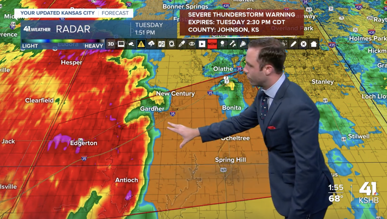
2:16 p.m. | A severe thunderstorm warning for a large swath of the Kansas City area is in effect until 3 p.m.
Severe Thunderstorm Warning continues for Overland Park KS, Kansas City KS and Olathe KS until 2:30 PM CDT. This storm will contain wind gusts to 70 MPH! pic.twitter.com/njTL6xJL5H
— NWS Kansas City (@NWSKansasCity) June 3, 2025
The following Kansas counties are included: Wyandotte, Miami, Leavenworth and Johnson.
The following Missouri counties are included: Cass, Clinton, Clay, Ray, Caldwell, Lafayette, Platte and Jackson.
2:10 p.m. | The National Weather Service has issued a new tornado warning for southeastern Johnson County, Kansas, as well as northwestern Cass County and southwestern Jackson County until 2:45 p.m.
Tornado Warning including Grandview MO, Loch Lloyd MO and Unity Village MO until 2:45 PM CDT pic.twitter.com/G1rOmCoEi2
— NWS Kansas City (@NWSKansasCity) June 3, 2025
2:03 p.m. | While the tornado warning has expired, a severe thunderstorm warning remains in Wyandotte, Miami, Johnson (KS), Leavenworth and Platte counties until 2:30 p.m.
Severe Thunderstorm Warning continues for Overland Park KS, Kansas City KS and Olathe KS until 2:30 PM CDT. This storm will contain wind gusts to 70 MPH! pic.twitter.com/njTL6xJL5H
— NWS Kansas City (@NWSKansasCity) June 3, 2025
1:47 p.m. | The National Weather Service has issued a tornado warning for northwestern Miami County and southwestern Johnson County. The warning will expire at 2 p.m.
1:42 p.m. | Watch KSHB 41 Weather's latest forecast in the video player below.
