


Good Thursday blog readers —
A cold front is breaking the heat streak in Kansas City tonight, bringing cooler temps and a chance of showers or thunderstorms.
While severe weather is less likely here, be prepared for gusty winds and heavy rain.
This could be the last triple-digit feel for the year. So let's talk some heat history.
Heat history
The hottest temperature so far this year has been 99 degrees (heat index 108 degrees), which interestingly occurred on the same day as the hottest temperature last year, when we reached 103 degrees.

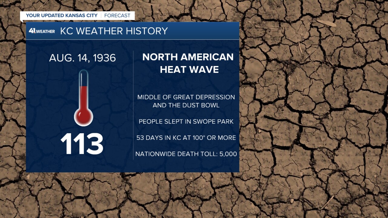
The hottest temperature ever recorded in Kansas City history occurred on Aug. 14, 1936, during the Dust Bowl era.
This record was part of a broader North American heat wave.
During the Dust Bowl, KC experienced record-breaking temperatures, including 53 days at 100 degrees or more.
A combination of factors caused this extreme climate: drought, increased soil erosion, and decreased vegetation cover reduced the Earth's ability to absorb and reflect sunlight, leading to higher temperatures.
High-pressure systems also trapped warm air over the region.
The Dust Bowl serves as a historical precedent, demonstrating that we've already had a hand in shaping our climate.
However, it also shows that we have the power to make a positive change.
By working together and adopting sustainable practices such as improved agricultural techniques, government intervention, natural factors, and economic changes, we were able to improve the quality of life across the Great Plains.
We've faced this challenge before in the Plains and we can overcome it again.
Are we done talking about extreme heat?
It seems likely that this week could mark the end of the 105 degrees heat index.
While there's a possibility of another heat push around mid-September, think September 10-15, it's uncertain at this time.
Remember: Average September temperatures range from 84 degrees to 74 degrees, and the last typical 90 degree day is usually around Sept. 9.
Storms are brewing
The end of all this heat is due to a cold front coming into town.
This will bring some rain and thunder through the afternoon and a chance for strong to severe storms overnight.
This Afternoon (now through 8 pm): As the cold front moves southward from Minnesota, it will create conditions that are favorable for thunderstorms to form.
These storms are most likely to occur in the afternoon and evening, and they will move southwestward into northwest Kansas and northern Missouri.
However, these storms are more likely to be scattered showers than widespread severe weather.
Here is a look at what radar could look like by 4 p.m.

Overnight (10 p.m. through 2 a.m.): The strongest storms are expected in northwest Kansas, northwest Missouri, and northern Missouri.
These storms could bring heavy rain, hail, and strong winds. This is our severe weather window.

The cold front should quickly weaken as it moves toward the metro area.
By sunrise, only scattered rain showers and maybe a rumble of thunder should remain.
Here is what radar could look like by 10 p.m. and 4 a.m.


Friday:
Expect some lingering rain showers along I-70 and north this morning.
However, we should start to dry out by the afternoon, and the skies should clear up by evening.
This will leave us feeling refreshed as temperatures will be below average for the next five days.
We're looking at a mild and dry Labor Day weekend.

—
