


Good Monday morning, weather bloggers —
We're easing into the cold, snowy conditions today as a band of heavy snow moves through northwestern Missouri into central Missouri.
Parts of Kansas City and the Northland have received a dusting to 1" of snow already this morning, which has covered a few surfaces and area roads. Please be careful early today!
With this round, the heavier snow amounts will likely stay across northern Missouri where 1-3" of snow is possible. A winter weather advisory is in effect for northern Missouri and Kansas until 6 p.m.
Scattered snow showers overnight and bands of snow will gradually fill in and increase in coverage heading into Tuesday morning and early afternoon.
Bursts of heavier snow are possible from 10 a.m. to 6 p.m., especially south of I-70, where accumulation totals look to be the highest.
Generally, 3-6" of snowfall can be expected for the entire Kansas City metro, with higher amounts falling in the southern half.

Most of the accumulation concludes around 10 p.m. as temperatures fall near zero. The bitterly cold temperatures will make the snow very light, easier to blow around and shovel ... but not good for snowballs.
You won't want to spend much time outside playing in the snow as wind chill values following the snowfall will be extremely cold.
A cold weather advisory (formerly known as a wind chill advisory) is in effect from 9 p.m. tonight through 6 p.m. Wednesday. That is then followed by an extreme cold watch for Wednesday to Thursday.

Morning wind chills Wednesday and Thursday morning will be near -25°, and the afternoons may not feel warmer than -10°.

There won't be much melting done until Thursday when sunshine warms up the pavement, so prepare for a couple of days of snow-covered roads.
Our forecast low temperatures Wednesday-Friday break the record low temperature for all three days. This is some seriously cold air.
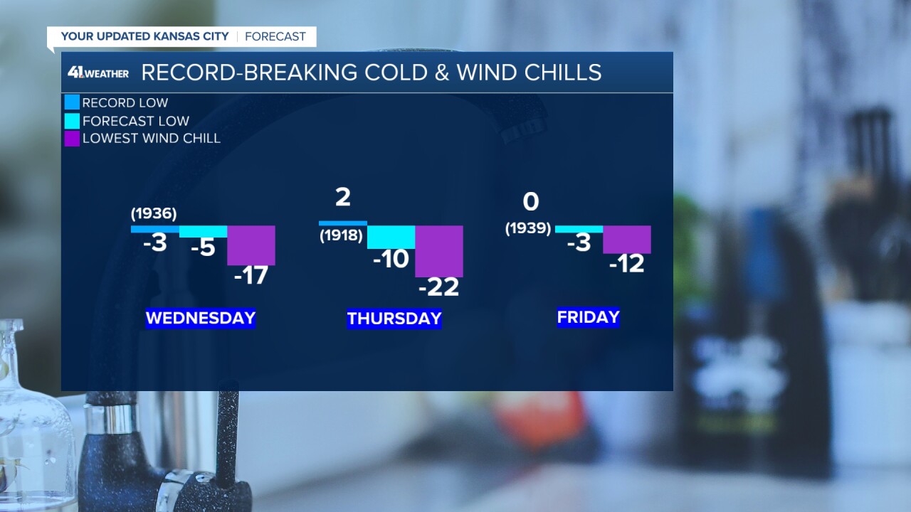
Wind chill values finally rise out of the negatives by Friday afternoon, setting the stage for a much warmer weekend. It may be in the 40s and 50s next week!
Please stay safe this week!
—
