


Good Tuesday evening blog readers —
We're in for some weather whiplash in the next 24 hours.
Today temperatures struggled to even get into the low 70s with persistent light rain for much of the day.
Tomorrow we go from 70s to feeling like 100 degrees again with more rain pushing in that could be a bit more stormy.
We're going to break it up like this, first some storms, then some heat, and then some more storms.
First round of storms: overnight
Our warm front will start to lift into the region and spark storms after midnight.
These storms may stay right below the severe threshold overall so expect heavy rain and noisy thunder to be the most prominent impacts.
A few storms could produce strong winds and small hail.

It looks like storms will kick into gear by 12-2 a.m. into early Wednesday morning near the Kansas City area core.
These storms then lift and will mainly impact areas north and west of Kansas City through Wednesday mid-morning.
Here is a look at how radar could look by 6 a.m.
It should be dry for those on the Kansas side heading back to school Wednesday.

Then the heat: Wednesday 1 to 7 p.m.
This warm front will lift storms north but the humidity that lingers will join some heat to create some concerning heat indices around the area.
We expect the heat index Wednesday afternoon to be near 105 degrees for areas southwest of the stormy weather.

Second round of storms: Wednesday into Thursday
The next round of active weather arrives with the trailing cold front Wednesday night into early Thursday.
A cold front passing will create a slightly higher risk for storms to become severe.
Overall, with this batch, we are still watching for low-end severe impacts.
Those include damaging winds and quarter size hail.
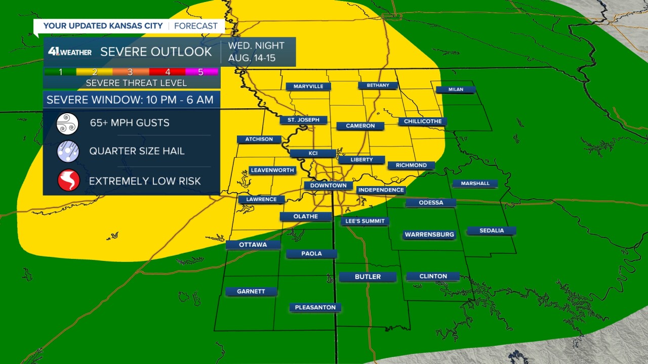
Storms will favor areas north of Kansas City and will kick off near the Maryville-Atchinson line by 9-11p.m. Wednesday.
As we head through the night, the Kansas City area isn't expected to see storms until closer to 2-4 a.m.
The storms will have a better chance to become severe before midnight and will be pushing more east to south east; this will keep the Kansas City area impact on the edge of the action.
Here is a look at how radar could start around 10 p.m. versus how it could look by 3 a.m.


Expect some lingering rain to impact the Thursday morning back to schoolers, but this should be the end of the morning storm impacts.
There is a chance some storms return late Thursday but should more-so toward the Ozarks by this point and heading on out of the area leaving us with a dry forecast by Friday.
We've seen 2-4 inches in a few pockets around the region over the last 48 hours and over the next 48 hours we could add another 2-4 inches, especially on the Missouri side.
Areas from St. Joseph to Sedalia will get hit by the warm front and the cold front so they get to double dip. While areas on the Kansas side will get lucky to tap into one or the other.

