Happy New Year blog readers —
January is a month that likes to cold and the snow... so let's just get right to it!
Thursday we've got a weak sauce system brushing by to our north, but this weekend, oh boy, that's where things get interesting.
Thursday
Expect a cloudy and chilly start with light snow for areas north of Highway 36 through the morning. This should remain mainly a dusting and anything that does stick will stay under 1 inch.

In Kansas City, we should see the sun try and come out a bit through the afternoon with temperatures staying mild and in the mid to low 40s.
But that's about it for mild temps for a bit. By Friday, high pressure wraps in and pulls in some chilly air, kicking off a nine-day cold snap. Heads up, cold snap does include some nasty arctic air as well!

Weekend
When it comes to this weekend here are the main things I want you to be aware of:
- There is some ice potential (and could impact I-70 and areas south)
- There are some big snow zones possible (especially to the north of the metro... but the main bullseye is TBD)
- This all comes during a really cold portion of our forecast
The ice concern looks likely as this system will pull in with some warm air initially.
Expect Saturday between 4-6 pm to see a mix of precip coming into focus. I think we could see some accumulating ice near the I-70 corridor and areas south.
I'm really keeping a close eye on our Kansas friends near and along I-35. So if you are in these areas, make sure to stay up to date with the ice potential and how this forecast evolves. A small nudge north of south can make all the difference.


As we head toward sunrise Sunday the ice potential starts to fade and we will see the back side of this system — the cold air and the main snow potential start to kick in.
Tracking where the low moves will be key in where the biggest snow will hit. The area we watch for is called the deformation zone, this is the area behind the low where the heaviest snow bands form. Right now, that looks to hit by midday Sunday... but that can change still and a small shift in the low can create big ripples in where the heaviest snow hits.

So right now, models are spitting out some high snow totals because they are banking on that deformation zone to hit right over Kansas City.
Some have totals in the 6-10 inches range, but right now I think it's a safe bet to expect somewhere between 3-6 inches around the metro core.

Stay tuned to this snow forecast though as we narrow in what will hit where and when a little better. So when it comes to trying to hit the half foot mark in the metro, while models might be hinting that way, remember forecasting is a science and here are some things to ground that number a bit.
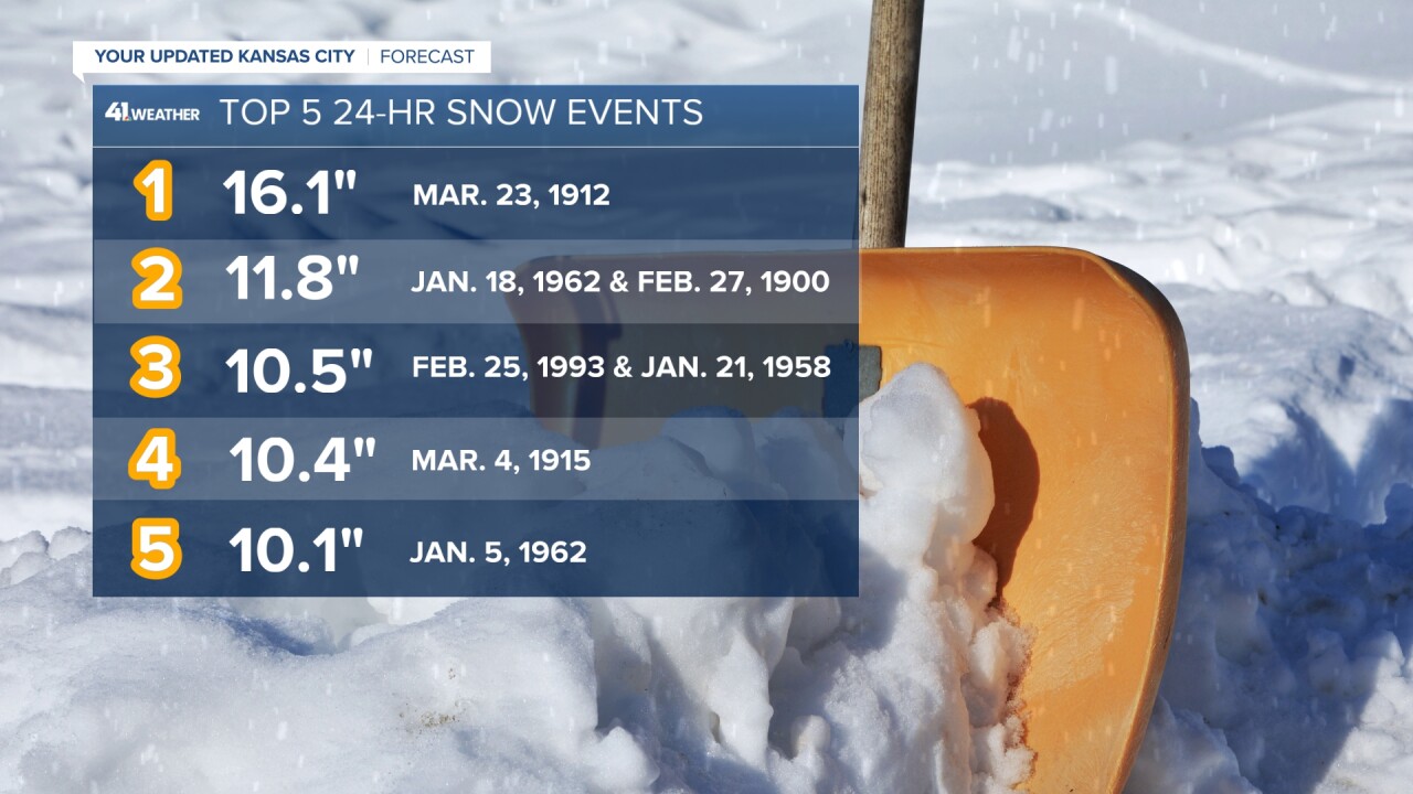
The most snow we've ever seen in a 24-hour period is 16.1 inches back in 1912.

If we look at the most recent snow over 6 inches that was back in the winter of 2022 when a snow storm brought 7 inches of snow to KCI. But keep in mind when it comes to getting a snow to measure at least 6 inches, it has only happened 68 times in KC's history!
That's a very small amount when you think about the fact we've had 49,673 24 hour periods of record keeping. That means 6 or more inches of snow falls 0.14% of the time.
But Cassie, it really only snows a few months out of the year. Well, that doesn't change the stat. 16,557 winter days have been tracked in Kansas City and only 68 of them have seen a "big snow," which means we are still talking less than 1% of winter days.

All this being said, this will be the biggest storm of the year or past two years possibly, and we will be updating you around the clock.
So make sure to follow the entire KSHB 41 weather team as we work through ice, snow and cold weather through the next week!
And remember to be kind to each other.
—


