

TGIF blog readers!
It has been a rainy week around the Kansas City area with some of our neighbors getting upward of 3-5 inches of rain!
Take a look at north central Missouri's estimated seven-day rainfall.
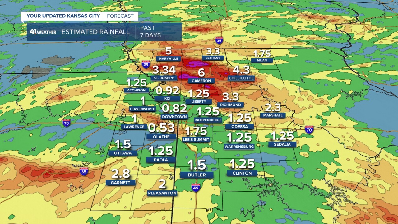
Around the Kansas City area, we saw light rain with a few pockets of heavy rain into areas southeast of KC, but our peak rain regionally hit Aug. 14 with that warm to cold front combo picking on north central Missouri.


Official rain at Johnson County Executive Airport was barely over 0.5 inches despite many through Overland Park receiving 2-4 inches of rain Sunday into Monday this week.
But out toward Chillicothe, their airport returned almost 4.5 inches of rain, with some cities and towns through north central Missouri registering nearly 6 inches of rain this week.
It's easy to see on our drought monitor where the rain has been favored this season; there is a nice hole missing in north central Missouri.
Portions of Kansas between Ottawa and Atchison remain drought free as well.

The bright yellow indicates abnormally dry conditions, while the tan mean moderate drought is present.
This is a pretty great reading to see at the end of the summer.
Here is a breakdown of what these two categories mean.
- Abnormally dry: We are stating to see signs that we could go into drought such as short-term dryness. Impacts include; slowing planting, slower growth of crops and pastures, and fire risk is now above average;
- Moderate drought: We can expect some damage to crops and pastures. The fire risk is high while streams, reservoirs or wells start to show lower levels. Some water shortage developing or imminent, voluntary water use restrictions requested.
There is one more chance for rain this week before we shift gears to a dry pattern for a bit.
We are monitoring a cluster of storms moving through central Kansas this afternoon to bring rain chances to areas near I-70 and southeast through your Friday night.


There isn't a lot of severe weather to talk about with this complex as Kansas City remains in the general risk.
Franklin, Linn, and Anderson counties in Kansas and Bates County in Missouri are in a level 1 out of 5 for severe weather concerns.
This means we will watch for some storms that could become severe and producing damaging wind and hail.
The risk in the Kansas City area includes lightning and a few quick thundershowers, but everything should stay well below the severe threshold.
Here is what radar could look like by 5 p.m. and then 7 p.m. this evening.


The one area of concern to watch will be a line from Emporia, Kansas, into the Ozarks for stronger to severe storm potential.
The rest of this complex should weaken as it approaches, but we can't rule out getting wet for a short period of time between 7 and 9 p.m. tonight.

The good news is, after tonight, those rain chances really fall off and there isn't a clear signal when they will return.
So get ready to enjoy a sunny, warm but humid weekend.

We are liking a "Travis Kelce" style forecast for the first game back at GEHA Field at Arrowhead Stadium this year.
The last time Chiefs football was played at Arrowhead, it was the coldest game in Chiefs history.
Safe to say we are going from freezing the fish to giving those felines a fever — the Chiefs are back at GEHA Field at Arrowhead!!!
It will be 90° warmer this Saturday compared to the last time the Chiefs played at GEHA Field at Arrowhead! Looking great in Kansas City for the first home preseason football game!@kshb41 pic.twitter.com/Dt7y8giZAt
— Lindsey Anderson (@lnanderson) August 16, 2024
Have a great weekend, and get ready for a slightly cooler and dry pattern next week!
—
