KANSAS CITY, Mo. — Good Friday bloggers,
We have been and still are tracking a large and slow-moving storm system. The main storm is sitting over southern Arizona as a decent upper -level disturbance tracks or actually races up Interstate 35 ahead of the main storm. The rain is moving northeast at 80-90 miles per hour.

The main storm will track out of the southwest USA this weekend, exiting the middle of the USA on Sunday.
So, let's go through this.
FRIDAY MORNING:
The leading edge of the rain was just southwest of KC at 5:30 a.m. Since it is racing northeast up I-35 at 80-90 mph it will arrive during the morning rush hour. The rain may get a speeding ticket! But, it won't slow it down. The first area is a thin arm attached to a big body of rain.

FRIDAY (noon to 7 p.m.):
The rain will be occurring across all locations. It will be mostly light to moderate, but some heavier downpours and perhaps a thunderstorm are possible. Highs will struggle to 50° with a NE wind at 10-20 mph. So, chilly for sure.

FRIDAY NIGHT:
The main rain will exit between 5 and 8 p.m. Then we will see lingering showers and drizzle with temperatures in the low 40s. The wind will pick up from the north to 15-25 mph. It is going to be a chilly Friday night.

Since the storm system is moving so slow, the areas seeing severe weather and torrential rain will continue to see it through the weekend. There is a level 4 of 5 risk today from east of Dallas to southeast Missouri.

SATURDAY:
The main storm system finally starts to move and the last main area of rain makes to right around Interstate 70. Some data has the rain staying south of Kansas all day. If the rain does make it up into Kansas City, the best chance will be during the morning into the early afternoon.
Highs will be in the upper 40s with a north wind 15-25 mph. So, a cold April day. The average high is in the low 60s.

The severe threat on Saturday is about in the same place as it is on Friday, but slightly farther east. It still includes southeast Missouri.

SATURDAY NIGHT:
The rain moves to the east as we will be mostly cloudy, dry, windy and cold with temperatures dropping to the 30s with a north wind at 10-20 mph.

SUNDAY MORNING:
The main storm will be moving by with lows in the low to mid-30s. Yes, that is snow about 80 miles south of Kansas City at 4 a.m. Sunday. If the storm tracks a bit farther north, we could see some snowflakes. In the snow area grassy surfaces could get coated white. Some paved surfaces could have slick spots for a short time.
Yes, it is way too early to put out delicate plants. The average last freeze date is next week. But, you can get a frost/light freeze into early May.

SUNDAY AFTERNOON:
The storm system exits to the east. We will see increasing sunshine and temperatures with decreasing wind. Highs will be in the low to mid-50s with a north wind at 5-15 mph.

The severe threat shifts to the southeast USA before the storm exits the USA on Monday.

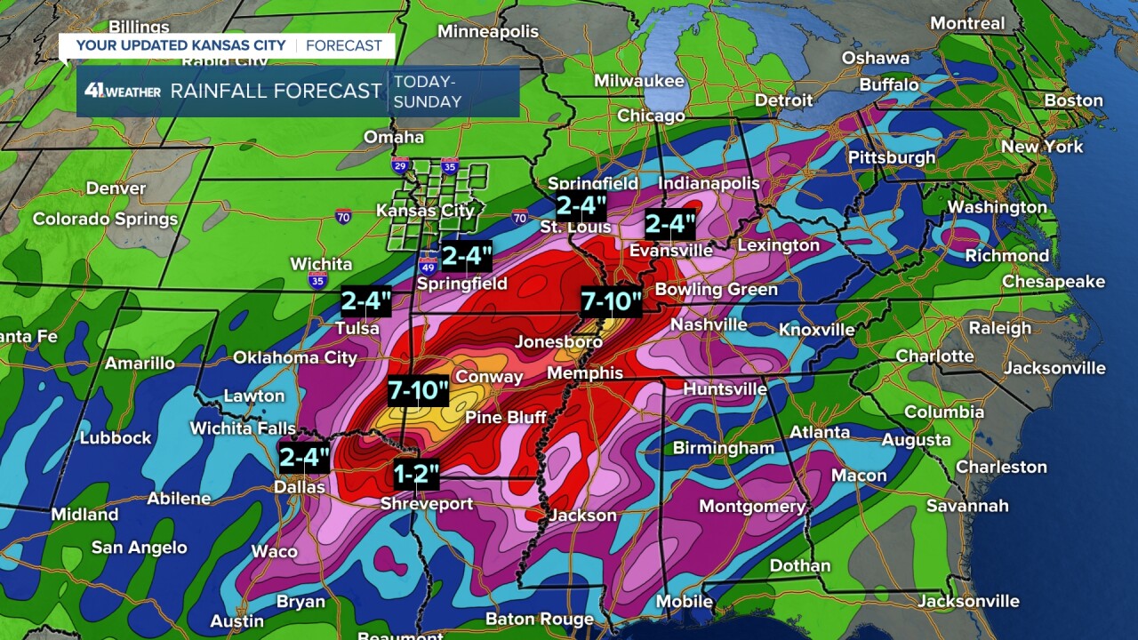
RAINFALL FORECAST TODAY-SUNDAY:
These are radar-estimated rainfall totals the last five days. Most of this rain has occurred during the last three days. 2"-7" of rain has occurred from Arkansas to southern Ohio. We have seen around 1" of rain.

An additional 3"-10" of rain will occur on top of the 2"-7" of rain that has already fallen from Arkansas to southern Ohio. This will create considerable flooding issues.
Flooding kills more people per year than tornadoes and lightning combined. "Turn Around Don't Drown." 6" of flowing water can float an SUV.
Unfortunately, the areas seeing flooding rain will also have tornadoes and lightning.

Our region will see .10"-.50" of rain with .50"-1" just to the southeast. The .50"-1" rain line could shift north by 30-50 miles. The north edge of the excessive rain is about 100 miles to the southeast of KC.

WEEKEND WEATHER SUMMARY:
The main rain occurs today with drizzle a few showers tonight. Rain will be most likely Saturday morning into the afternoon, mostly south of I-70. It will be cool as well with temperatures mostly in the 40s. 30s arrive Saturday night.

ORIOLES AT ROYALS:
The games should get played with some rain lingering tonight. Any rain Saturday will be ending. But a brisk north wind and temperatures in the 40s will make it a bit chilly. The weather looks best on Sunday.

SPORTING KC vs. ST. LOUIS:
It will be dry for the game, but cold with temperatures dropping to the 30s and wind chill values in the 20s.
If you are heading to CPKC stadium for the International Day game, Mexico vs. Jamaica, it will be mostly dry. There could be some very light rain lingering as the match starts at 4:30 PM. Otherwise, it will be windy with temperatures in the low to mid-40s.

Have a great weekend
Stay healthy


