Happy Halloween blog readers-
We've had some wicked winds this week! Monday & Tuesday windy weather knocked out power as they gusted above 50 mph at times.
KC we are blowing A LOT of hot air today!!! @KSHB41 pic.twitter.com/y968QTq4bB
— ☀️ Cassie Wilson (@CassieKSHB) October 29, 2024
By Wednesday, we were tracking a strong cold front to push severe storms through the area with wind as our main focal point for impact. The SPC has 123 storm reports acorss the Great Plains yesterday and 111 of them ended up being wind related. In Atchison, KS we had one concerning potential spin up along this line of storms, but no that warning went unfounded.
We now have a tornado warning for Atchison, KS. Tune into KSHB 41 on air and online to track this. https://t.co/URHvJDGLVt
— Caitlin Knute-KSHB 41 News (@CKnuteKSHB) October 30, 2024
The good news about last night:
- The storms remained low end severe
- We got some healthy rain
Remember just about a week ago we were talking about this October trending as the driest ever in KC history! Well we will still be ending the month in a rain deficit, it's good to see rain in the forecast.

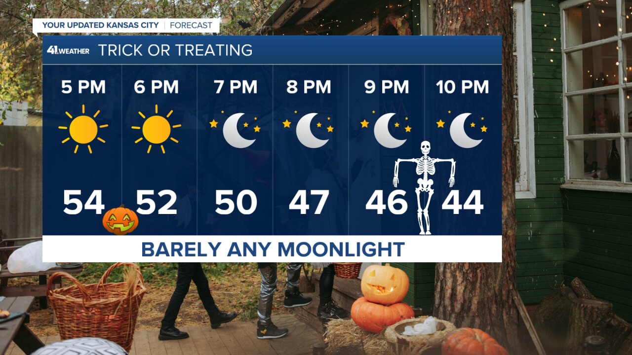
This has all set the stage for a cool but not bone-cold Halloween in Kansas City. As we head into the evening, trick-or-treaters may need a jacket or a sweatshirt layer to their costumes. Temperatures will be in the low 50s and upper 40s for much of the night. By Friday morning though, expect to start the day in the upper 30s.

High pressure will keep us quiet and sunny for Friday, but there is more wet weather loading for the weekend. We are watching for some showers to pulse north Saturday, but I don't think it will rain all day for everyone! There just isn't a lot to organize Saturday storms, but by Sunday we start to deal with low pressure organizing a warm front that will sweep through. This will bring thunderstorm activity into the mix.

The bigger day to watch for stormy weather is looking like Monday, and yes I am aware of what is going on here! Monday Night Football plans, it's time to create an inclement weather plan for the game. The Storm Prediction Center has already placed us in a level 2 risk for severe weather concerns.


Between this weekend and early next week, we are looking at some solid rain chances across the Great Plains and it looks like we have kicked off a new pattern.

Just keep in mind, this time of year any low that pushes through will have the potential to be wrapping snow into the back side of it. So while we are watching rain in the Kansas City Area, Denver and our friends northwest of us on the cold side of these system will be tracking snow.

There is a lot of exciting things lining up with this pattern change and it will be an interesting few weeks to watch how the weather unfolds across the United States. In the mean time, enjoy the quiet but cool weather today and Friday.
Stay safe out there tonight with those kiddos and have a fun Halloween!


