KANSAS CITY, Mo. — Good morning bloggers,
A three-day storm is on the way and it will begin with a 100% chance of rain before sunset. And a suggestion: get the winter coat ready and don't put it away for the season. Some snow is possible with a mid-week cold surge.
Severe weather season is about to begin in our region, but it appears we will be just outside of this week's severe weather risks.

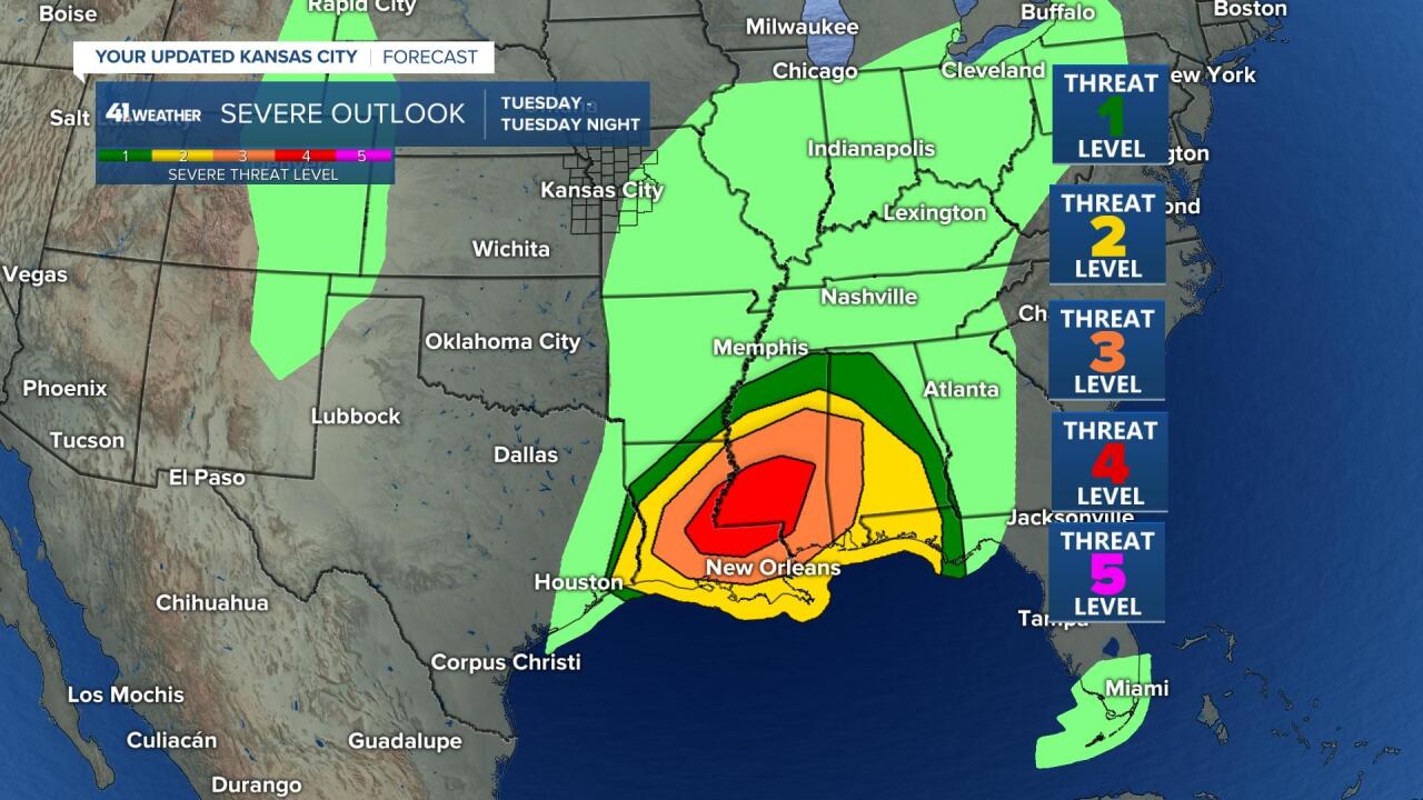
This setup for Tuesday would produce a severe weather risk in Kansas City if it were lined up just a bit differently. We still have to pay close attention to how tomorrow sets up with that eastern Kansas surface low approaching, as you can see above. Here are the risks for the next two days.


There is a level four risk for severe weather for tomorrow over Louisiana and Mississippi, where strong tornadoes are possible. Since I created this severe weather risk graphic last night, it has already been upgraded in our area. As discussed above, there is a surface low tracking our way tomorrow morning and there may be enough instability for a few severe thunderstorms to form as this system moves by. Here is the updated risk just out:

The MRGL stands for "marginal," and this is a level one risk in our area tomorrow.
Between now and Tuesday, part one of this storm will arrive with a 100% chance of rain by this evening. It will warm up into the 70s ahead of the rain. With clouds streaming overhead, the high will probably get close to 70 degrees in Kansas City after yesterday's high of 77 degrees.
Looking into Tuesday's potential severe weather risk:

From the SPC for far eastern Kansas and into Missouri
"As an upper-low moves out of eastern Kansas and across Missouri Tuesday, cold air aloft/steep mid-level lapse rates will reside across the area. An eastern Kansas surface low is likewise forecast to shift into and across Missouri with time. As modest daytime heating of the warm sector occurs, increasing low-topped, surface-based CAPE will support the development of showers and scattered thunderstorms. A few stronger storms will likely evolve. As such, hail, and a few damaging wind gusts will be possible, and even a tornado will be possible in the cold-core-type setup. At this time we will introduce an MRGL risk area, but upgrade to SLGT could be necessary for later outlooks."
We will be looking for any clearing and warming of the surface. If it is in the 50s, then we are less likely to have severe thunderstorms form. If it warms up a few more degrees into the 60s ahead of this Tuesday part of the storm, then severe weather becomes more likely. We will be monitoring how this sets up tomorrow. There are parts of the Kansas City metro area that have not been in a tornado watch in almost three years. This is part of our discussion in our weather special on March 29.
Kansas City weather timeline:
- Today: Increasing and thickening clouds with no chance of rain before noon. The chance of rain will increase to 100% by sunset. South winds 15 to 30 miles per hour. High: 70 degrees
- Tonight: Cloudy with a 100% chance of rain. A few thunderstorms are likely. Rainfall amounts of a half-inch are expected with over 1-inch possible where the heavier thunderstorms occur. Low: 51 degrees
- Tuesday: Periods of clouds mixed with some sun. There is a good chance, 50% chance of showers and thunderstorms. A few of them may briefly be strong or severe near and east of the Kansas-Missouri state line during the late morning into early afternoon. High: 60 degrees
- Wednesday: Cloudy with a chance of rain and snow showers. High: 39 degrees
In summary: Part one of this storm will spread beneficial rain over our area later today and tonight; part two of this storm produces a lower end severe weather risk in our area Tuesday; with part three of this storm producing a chance of rain/snow showers on Wednesday!
Thank you for sharing this weather experience and spending a few minutes of your day reading the weather blog. Have a great day!
Gary


