Welcome back Weather Blog readers.
It has been pretty cold to finish out January but the first week of February is looking nice and warm. But of course that will come with some windy days.
Advice to golfers out there, better get those reservations at your favorite golf course in now because a warm up is coming this weekend.
Cold here, but at least it's not icy
It is a dangerous icy mess across Texas and the Mid-South where there are tons of winter storm warnings, advisories and ice storm warnings. This is happening because of something called "overrunning"
Overrunning occurs when less dense, warm and moisture air is advected over cold, more dense air. The result is precipitation that is frozen as it falls(sleet) or freezes on contact(freezing rain).

The jet stream, which is responsible for our large swings in temperatures, has a dip or trough in it, which is both allowing for cold air to move south and dig far enough south it has lifted in moisture,

By the weekend our jet stream develops a small ridge or bump, allowing for warm, moist air to again advect further north into the Midwest.
Notice the orange colors creeping a little closer to us? That is the atmosphere expanding in response to warmer air.

Weekend warmth
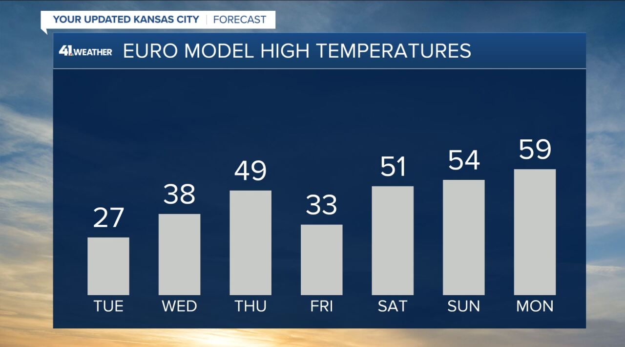
We continue to get good agreement by our weather models of highs in the 50s and possibly 60s coming for the weekend and next week.
Here are two of the many weather models we look at daily for our forecasting, the American GFS model and the European model


There are a few factors that go into determining how warm a day may actually be compared to what the models think will happen. Factors like cloud cover, wind speed, and wind direction may cause models to underestimate how warmth.
For example, Saturday weather models have us at 51 and 52.
Well look at the wind speed and direction Saturday...

It is southerly or southwesterly with gusts near 35 mph. A south wind, no matter the cloud cover, will usually cause us to be warmer than models predict. Our wind is out of the south because we are caught between a high to our east and low to our northwest.

Air travels from high to low then bends to the right and there you have a south wind!
I think high temperatures Saturday-Sunday will be in the middle 50s to middle 60s! The wind will be strongest Saturday but it will be sunniest Sunday so both days could end up with a very similar temperature.
From a golfers perspective, Sunday will be the choice day.

You can find my weather updates on social media @WesWeather.
Enjoy your weekend and thanks for reading!


