KANSAS CITY, Mo. — Good morning bloggers,
I am not sure how significant this record is to you, but to me it just blows my mind. We have literally gone three full years without me explaining how the ingredients are coming together for significant severe weather. Three straight years!
We have some really great storm chasers that you don't know because we have practically not needed them since that one big day three years ago.
The last tornado watch that was issued for the entire Kansas City metro area was three years ago. It was the day we had the scary EF-4 tornado that destroyed homes in Linwood and caused damage near Lawrence on May 28, 2019. Three straight years without a tornado watch in Johnson and Wyandotte counties.
For the other Kansas City-area counties of Clay, Jackson and Platte on the Missouri side there has only been one watch and it happened last fall.
Let's take a look at the tornado watches issued across the United States in the past three years:

The traditional Tornado Alley was as quiet as it has ever been in 2020 with no tornado watches across most of Kansas and the northwestern one-third of Oklahoma.
Last year, which is shown below, there was only that one tornado watch in Clay, Jackson, and Platte counties, but not one was issued in Wyandotte and Johnson counties. That one watch was issued as thunderstorms were developing near the Missouri-Kansas state line before the risk quickly moved away.

And, this season has somehow been extremely quiet once again. I am actually surprised as I was expecting a bit more activity in our area. There has yet to be a tornado watch this season in the entire KC metro area.

Add it up and this is three straight years without one. This makes 1,094 days in a row without a serious risk of tornadoes for the entire area.
Now, there were a couple of tornado warnings, just no watches. How is this possible? Tornado watches are issued when conditions are favorable for severe thunderstorms that may produce tornadoes.
Sometimes, when it doesn't seem like all of the conditions are coming together, a thunderstorm may still produce one. That's how we can get a tornado warning when there is no watch in effect.
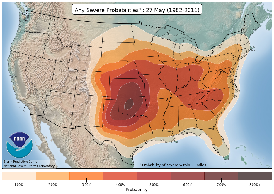
This next map shows the areas of the United States most likely to see severe weather annually on May 27:

This year, there is no chance of severe weather in Kansas City through Memorial Day.
Memorial Day weekend is climatologically the wettest weekend of the year, but not this one. It is going to heat up and be mostly dry. There is a slight chance of showers or thunderstorms early Saturday, but the rest of the weekend will definitely be dry and it will heat up.
The pools are opening up, and it's perfectly timed. Here is your forecast:
- Today: Mostly sunny and nearly perfect. Northwest winds only 5-10 mph. High: 78°
- Tonight: A great Friday Night In The Big Town. Low: 58°
- Saturday: A 20% chance of a brief morning shower, and then sunny and great for the pool. High: 85°
- Sunday: Mostly sunny with increasing south winds at 10-25 mph. High: 90°
- Memorial Day: Mostly sunny and breezy. South winds 10-25 mph. High: 89°
Thank you for sharing in this weather experience and spending a few minutes of your day reading the weather blog.
Have a great Friday!
Gary


