


Good Red Wednesday bloggers,
I can't believe the 2023 NFL regular season is about to start. Now, the Chiefs did have the shortest off season of any team. This is why it came up so fast. Let's try to have a short off season again!
CHIEFS SEASON OPENER (ON KSHB 41):
The weather looks great! It will be in the low 80s for tailgating, dropping to the 70s during the game. The wind will be light and there is no chance of rain. But, rain will be near after the game. We will have more on that below.
The one possible concern is the Canadian smoke. The smoke will be in our air from the surface up to 10,000 feet. This could cause an air pollution issue and a breathing hazard. It looks like the smoke will be thinning later tomorrow and at night.

————————————————————————————————————————————————————
CANADIAN SMOKE:
It looks like the smoke is emanating from fires in Saskatchewan and Alberta, north of Montana and North Dakota.
SMOKE FORECAST 5 AM THURSDAY:
The smoke will increase today from the northwest, peaking later tonight and early Thursday morning.

SMOKE (7 PM THURSDAY, JUST BEFORE KICKOFF):
The smoke is forecast to decrease, but it is not gone. We will see how this looks tomorrow.

The air quality is already deteriorating quickly from the northwest. This is quite rare to see air pollution issues in KC from Canadian smoke. It did happen earlier this summer, but the smoke combined with the heat and humidity and stagnant air. This is just the smoke moving in directly from Canada with no heat, humidity and stagnant air.
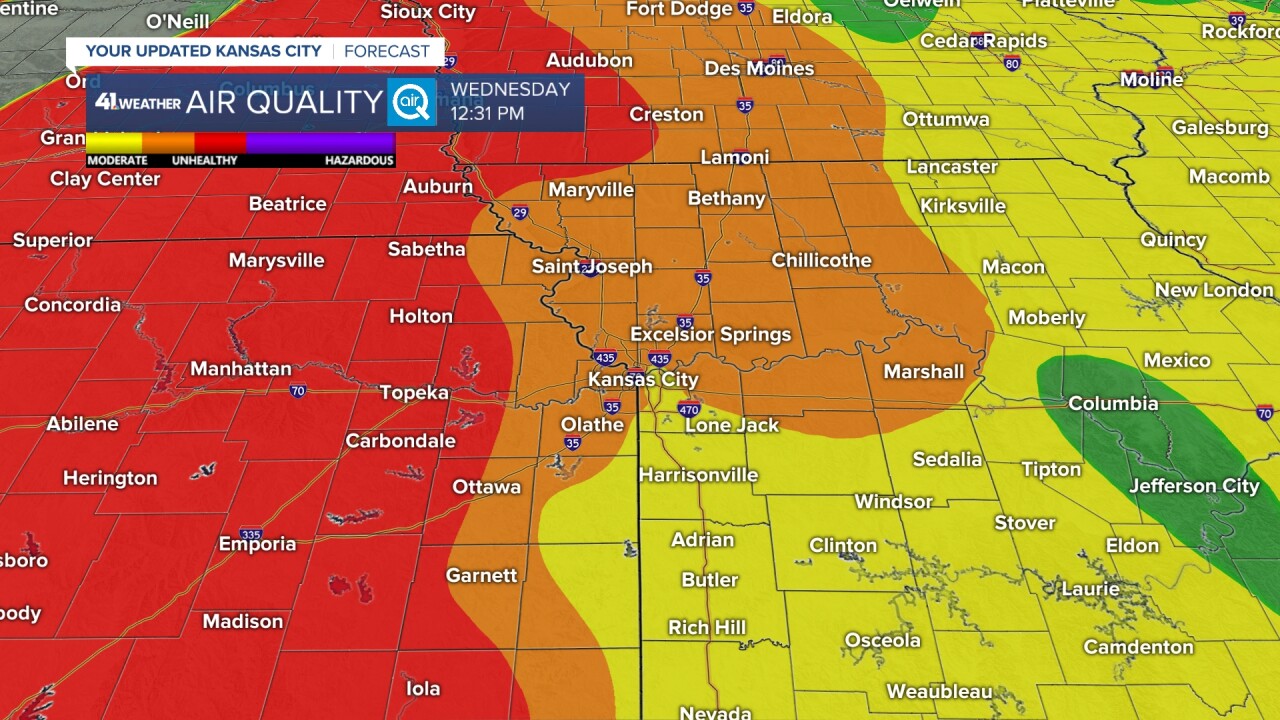
The poor air quality covers many locations that do not normally have bad air quality, Great Falls, Montana to Wichita, Kansas.

One of our latest air quality readings is at 132 and rising.

Right now we are in the Unhealthy for Sensitive Groups category (USG). It will likely rise to the plain Unhealthy category before the smoke moves out and thins by Friday.

————————————————————————————————————————————————————
SEARCH FOR RAIN:
The last three weeks, it has not rained in many locations with two bouts of heat. This really dries the ground fast. Especially, when the ground was barely wet enough to start. Yes, a few locations did see .25-1" of rain yesterday. It was about 1% of the area.
The average rainfall during the last three weeks for most locations is around 3.25". You can see the locations that have seen some rain are at 30% of average. Most locations are at 0% to 10% of average.

We do have some rain chances showing up.
Let's look at the next two rain chances.
The first chance is for later Thursday night into Friday.
TODAY:
There is no chance of rain, just the smoke issues. At least it is much more comfortable as highs will be around 80° with low humidity. A north breeze will be at 10-20 mph.

TONIGHT:
There is no chance of rain, but it will feel refreshing with lows in the 50s to low 60s. The air may be polluted from the smoke, so stepping outside and taking a deep breath to enjoy the temperatures may be unwise.
CHIEFS THURSDAY (4 PM):
There is no chance of rain as highs reach the low 80s along with a light east breeze. You can see highs may reach the low 90s just southwest of KC. You can see west of the highs in the low 90s is a band of clouds. This is the leading edge of a disturbance that may and usually does bring thunderstorms to our area this time of year.

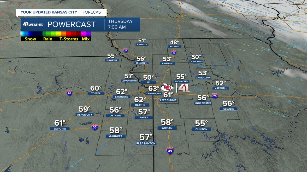
CHIEFS THURSDAY (7 PM):
The weather looks great for kickoff as long as we can thin the Canadian smoke. Temperatures will be around 80° with a light east breeze. The very upper left of the map you can see red and yellow, thunderstorms.

CHIEFS THURSDAY (11 PM):
The game should be over or close to over and the Chiefs should be 1-0. You can see clouds are increasing as the showers and thunderstorms enter southeast Nebraska. We will be around 70° with a light east breeze.

As we widen the view, you can see a nice cluster of thunderstorms in southeast Nebraska and new thunderstorms forming southeast of Wichita.

FRIDAY (2 AM):
Now we have two decent thunderstorm clusters. The one in northeast Oklahoma is moving away. The one in southeast Nebraska is crossing into Kansas and Missouri, heading this way.

FRIDAY (7 AM):
POOF! The rain and thunderstorms from southeast Nebraska arrive as sprinkles and a few rain showers. It falls apart as it gets here. Meanwhile, the second area of rain and thunderstorms grows in coverage and intensity across Arkansas as it moves away. Incredible.
Friday will end up being a nice day with highs in the 80s and a light east wind.

RAIN CHANCE #2:
It is timed for Sunday night and Monday. There is a trend for this to be less and less as we are on the eastern edge of the rain and it will struggle to get here.

RAINFALL FORECAST NEXT TWO WEEKS:
So, when you add up rain chance #1, rain chance #2 and a few others that are not covered in this blog, you can see around .10-1" of rain is possible. Northern Missouri may not see much rain at all. The heaviest looks to be across southern Missouri, central, western Kansas and central Nebraska. This can still shift around.
Average rainfall the next two weeks is 2.00". So, at this time, we are not hopeful for much rain.
The good news is that a new pattern will start to set up in three-four weeks. There is hope. And, there is always a chance that these next rain chances end up being more. But, the trend is towards drier.

Have a great rest of your week and weekend.
Stay healthy and Go Chiefs!
