Good morning bloggers,
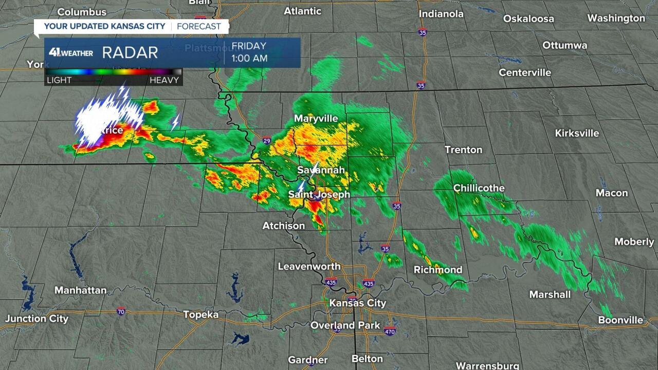
A band of showers and thunderstorms was moving in from the northwest when I was writing this blog at 1 a.m. It extended from St. Joseph to a strong thunderstorm in Beatrice, Nebraska. Here is a look at that radar image:

This is a very different scenario than Tuesday night and early Wednesday morning when we had thunderstorms suddenly produce four tornadoes (one in Johnson County, Kansas, one in Jackson County, Missouri, and two in Miami County, Kansas). That was the night I announced my retirement, and then Mother Nature got angry or something. There was no history of tornadoes with those thunderstorms until they got near KC.
This band of thunderstorms this morning is being monitored closely. There has not been one warning or watch issued so far. This area will track across the KC metro before sunrise.
Rainfall this month (before this band moved in):

Rainfall for the year:

Everything is lush and green. Three inches of rain above average for the year. It does look like some heat will build in next week with temperatures in the 90s likely for a few days.
This year's LRC will continue to produce cold fronts that will make it down here, so no prolonged heat waves are in the forecast. A heat wave is defined to be three-straight days in a row with 95° or hotter. We don't see one of those any time soon.
The flow at 18,000 feet above us: (Valid next Thursday)

This map above shows the developing "anticyclone." A cyclone is a storm system (hurricane, tornado, low-pressure system). An anticyclone is the opposite of a storm. The air sinks in the middle of an anticyclone, and this sinking air will lead to the heat building up. This system, or "anti" system, is forecast to develop over Oklahoma and Kansas later next week. We may have to raise our forecast high temperatures if this indeed does develop.
The weather this weekend looks great for Kansas City's Pride festival and for Symphony in the Flint Hills. I am speaking at 2 p.m. and 5 p.m. Saturday out there! I am looking forward to it. The topic is the LRC & Kansas weather.
I am then going to Milwaukee next week for the American Meteorological Society Broadcasters Conference. The topic there will blow your mind. I will be showing how Superstorm Sandy from 2012 is directly related to the pattern that returned the next spring to produce the last EF-5 tornado in the United States. The Moore and El Reno, Oklahoma, tornado set-ups are directly related to Superstorm Sandy, and the world doesn't understand. I will showcase this "order in chaos" that the LRC describes.
Thank you for spending a few minutes of your day sharing in this weather experience.
Have a great Friday Night In The Big Town,
Gary


