

Good Toasty Tuesday Bloggers —
The forecast is still a bit of a broken record, as we are still tracking near 90° heat. City air quality concerns and dry weather will continue through the rest of the week, too.
But there is something else to talk about: increasing confidence in some rain for the weekend.
Models have been fairly consistent in showing the formation of a shortwave system off the Rockies late this week, and with the heat and humidity we have building by the weekend, we are already watching this for severe weather potential.

The Storm Prediction Center has included Kansas City in a 15% probability for severe thunderstorms this Saturday.
We are expecting dew points in the 70s by the weekend, so it will be sticky out. There will also be enough vertical wind shear to support strong storm development.
We will watch for isolated storms to develop in the warm sector of this system through the afternoon, if we can break the cap. However, we may have to wait for the cold front to pass through for more widespread rain.
Right now, the timing for that looks to be at night into early Sunday.
Please note that this yellow polygon will change a bit in the coming days, so make sure you are staying up to date if you have outdoor plans Saturday.
In the meantime we are in a rain doughnut hole ... or maybe it's more of a croissant.

The next 72 hours will be sunny, hot, dry and, in the metro, we could continue to see air quality concerns. In general, this month has been okay so far with rain, so this hot and dry stretch doesn't alarm me, yet.
Take a look at this fun fact Lindsey Anderson found. Yesterday our rain total was PERFECTLY average! That is not something you see every day or all that often.

That good news stat is mostly thanks to the nice solid soaking the airport took Sunday morning. According to the NWS, the rain that fell Sunday was off the charts in a few ways.
As of Noon, Kansas City has received 1.38" of rain which makes it the third wettest day of the year just behind the 1.53" that feel on 2/9 and the 1.42" that fell on 4/19.#NoDroughtAboutIt
— NWS Kansas City (@NWSKansasCity) June 18, 2023
But not everyone around Kansas City is "safe" as we continue to see worsening drought concerns through central Missouri. Even some areas close to the metro, like Lee's Summit, have only seen 53% of their normal rain over the last 30 days. And southeast toward the Ozarks, Clinton is sitting at 31% of normal.
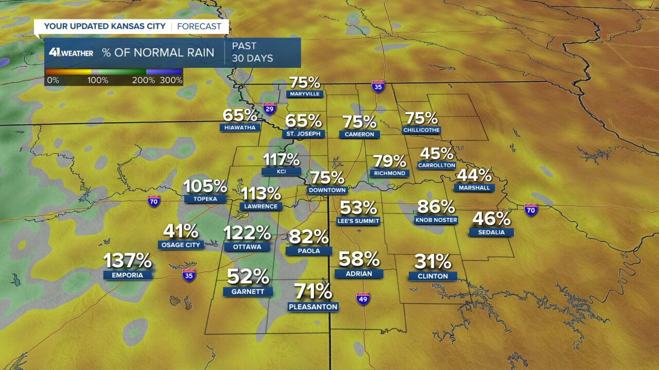
So it's safe to say that some spots are sitting in an okay spot, but many others are struggling. Getting some widespread rain this weekend would be beneficial.
Please stay tuned for updates to Saturday's forecast as we will be able to fine-tune things in the coming days.
—
