

Good Monday bloggers,
We are tracking three main issues this first full week of summer 2024.
These issues are the heat, Missouri river flooding and the chance to see severe thunderstorms.
Let's go through this.
The heat:
Today has been the hottest day of 2024 so far, as we have reached a high of 98 at 2:41 p.m. officially at KCI. It was 101 downtown.
It was never 98 on the hour as it was 97 at 2, 3 and 4 p.m.

Now, let's throw in high humidity and we get heat indices between 105 and 120.
Pleasanton, Kansas and Chillicothe, Missouri, is at 117!

Here is a look at the hottest temperatures in KC officially.
The hottest ever was during the "Dust Bowl" in 1936. We reached 113 on Aug. 14.
There was a period between 2014 and 2021 where we reached 100 officially at KCI just one time. That occurred in July 2018.
There were days over 100 in other parts of the city all those years.

Missouri River flooding:
The green are river flood warnings for the Missouri River and its tributaries. The red is an outline of the Missouri River basin.

The worse flooding is across southeast South Dakota, southwest Minnesota, northwest Iowa and northeast Nebraska.


The Missouri River is not over flood stage here, but it may work its way down the next seven days.
Now, being over flood stage, does not mean it is overflowing. There are tributaries in Minnesota and Iowa that are overflowing.

Why is this happening?
There has been 10 to 20 inches of rain during the last two to three weeks right over the Missouri River basin from southeast South Dakota to southern Minnesota!
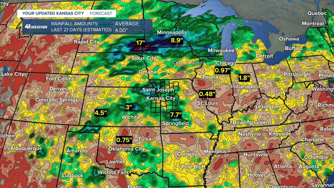
When you look in our region, many locations have seen four to seven inches and more. The average for a three week period this time of year is four inches.

But, notice the south side of KC to Clinton, Missouri — amounts are under two inches.
So, if you have not dragged the sprinkler out in these areas, your grass is getting brown fast.
It would be nice to get some rain without severe weather.
Even in the locations that have seen decent rain will see their topsoil dry out fast on days like this.

Here are some totals from around the area since May 1. The average is around 9.50 inches.
Most locations are below average. Some are nearly 50% below average.

So, what about rain?
There is a chance of thunderstorms every two to three days as we are in an active weather pattern tracking systems and fronts every two to three days.
Now, just because there are thunderstorm chances, it does not mean the rain will fall over the driest areas.
Rainfall forecast the next seven days:
The good news is that the locations that saw the 10 to 20 inches of rain will see the least, while the heaviest has a chance to affect areas that need rain.

If we can get this two to seven inches of rain the next seven days it will be great.
Now, you can see the driest locations do see the least one to two inches.
At this moment, we lean in this direction as this has been the pattern.
Could it change? Yes, but we need to see some evidence that is does before we go with anything different.

Severe thunderstorm threat:
The first thunderstorm chance to track is Tuesday and Tuesday night. It comes with a chance of severe weather.
We are in a level two of five threat. Damaging wind is the main issue.

Tuesday (5 a.m. to 2 p.m):
We may see a few showers and thunderstorms as a weak system drifts in from the west and a weakening line of thunderstorms drops south across central and eastern Missouri.

Tuesday (2 p.m. to 7 p.m):
We will be looking to the Iowa/Missouri border where thunderstorms will be forming. We will see highs in the low 90s due to more clouds, but the humidity will still be out of control.

Tuesday night (after 7 p.m):
The thunderstorms will increase and drop south toward Interstate 70.
They have the potential to bring very heavy rain, frequent lightning and 50-70 mph wind gusts.
This data has KC getting pounded between 8 p.m. and midnight.
As of now, there are still big questions on the timing of the line and also the location.
This line could pound the KC after midnight or as early as 9 p.m.
This line could miss KC to the east as it tracks south across central and eastern Missouri at anytime tomorrow night.
Bottom line: We will know more tomorrow. Will it break the trend of missing locations from KC to Clinton, Missouri?


Have a great week ahead, stay healthy.
—
