


KANSAS CITY, Mo. — Good Monday, bloggers —
We are in for yet another dangerously hot day as highs will climb to 95°-100° with heat index values 103°-110°.
The high on Sunday was 99°, which was the hottest day of 2024 so far.
Keep in mind, the temperatures we report and you see on your phone are taken 5 feet off the ground and in the shade. In the sun, you can add 10 degrees to the temperature and heat index.
The way out of this would be a cold front. If no cold front, clouds and a few showers and thunderstorms would help some.
Well, we are tracking all of the above, including two cold fronts.
Let's go through this.
TODAY:
The dangerous heat roars on today with few clouds. Highs will be 95°-100°.
The wind will be south-southwest at 10-20 mph which will help a tiny bit.
The first of two cold fronts we are tracking will be entering northern Nebraska.

TUESDAY:
The front we are tracking will get to northern Missouri and northeast Kansas. However, it will stall, so we won't get any cool air from the front.
Clouds, scattered showers and thunderstorms may form on the front and then drift our way. At the same time, clouds and a few showers and thunderstorms will be tracking in from the south, putting the squeeze on the high heat.
You can see we are in a smaller band of highs 90°-95°. We are looking at 93°, but if we reach 95°, that will make three straight days with highs at 95° or higher, which would be our first heat wave of the summer.


WEDNESDAY:
The front in northern Missouri becomes a warm front and moves back to Iowa. The second front we are tracking is entering Nebraska. This front will make it.
We will once again be in the 90°-95° range. In the temperature map below, you can see holes of cooler air in the main heat. This Swiss-cheese look is due to scattered t-storms forming due to moisture coming in from the south.
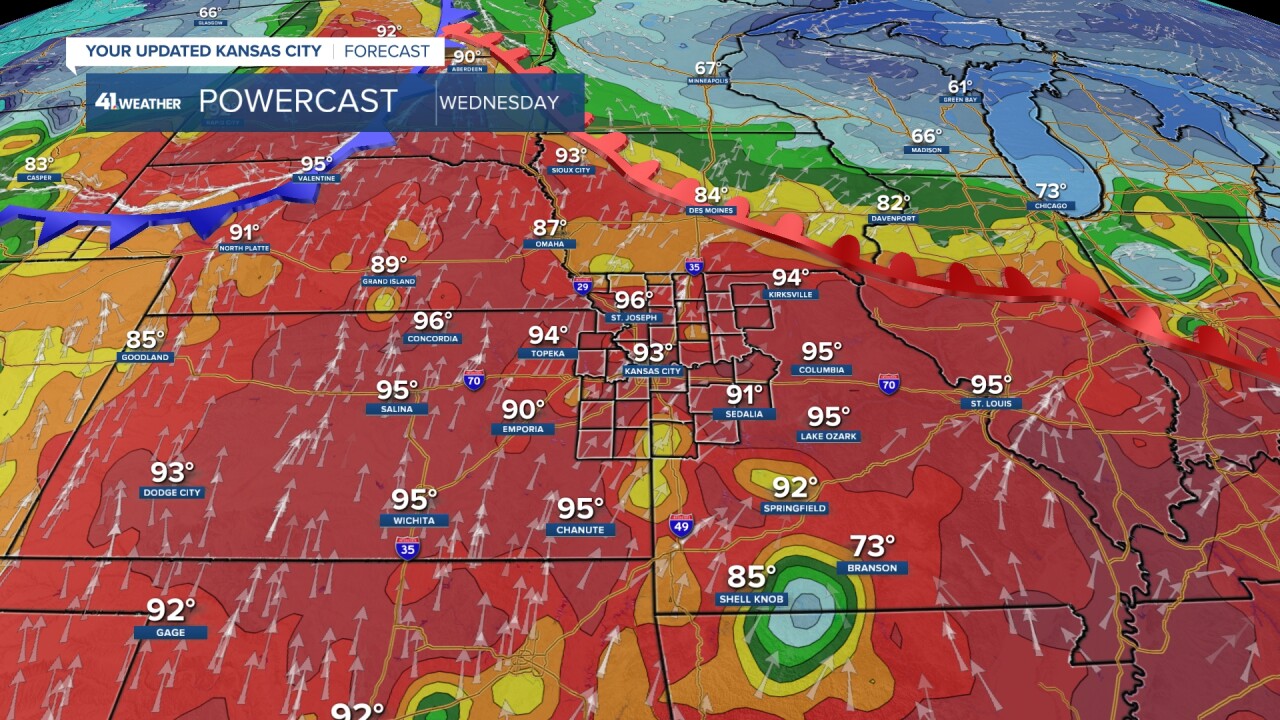
You can see the clouds and the scattered showers and t-storms around.

THURSDAY:
The second front is still on the move, now into southeast Nebraska.
We are once again in the 90°-95° range with the Swiss-cheese look in the heat due to scattered t-storms not associated with the front.

The t-storms associated with the front are forming to our west and northwest from western Kansas to central Iowa.

FRIDAY:
A round of more organized t-storms is looking more likely Thursday night into Friday as the front moves through.
Some severe weather is possible.

Highs will drop to the low 80s as the front moves by!

LABOR DAY WEEKEND:
Saturday and Sunday are looking nice with highs in the 80s and lows in the 60s, with lower humidity as the front pushes south.
A third front may sneak through Saturday night with no rain. If this happens Sunday, we will see highs around 80°.


LABOR DAY:
We will be tracking 1-2 systems in the Southwest that will likely bring us rain either by Labor Day or Tuesday.
At this time, it looks like the main rain and t-storms will hold off until Tuesday.
Right now, Labor Day looks dry with increasing clouds and highs around 80°.

WEATHER SUMMARY:
After we see dangerous heat today, the heat tapers a tad Tuesday-Thursday with more clouds and a chance of scattered t-storms.
A cold front arrives Thursday night-Friday with a better chance of organized thunderstorms.
This will pave the way for what is looking like a nice Labor Day weekend.

Have a great week ahead.
Stay healthy.
—
