


Good Saturday bloggers,
We are in for some super summer Saturday weather. But, the thunderstorm chances increase tonight and Sunday. We are also tracking Beryl. Will we see any rain from the tropical system?
Now, rain is something we do not need. Look at these rainfall estimated totals around the area during the last 30 days.
Average is 4.50"-5.00". There is a strip from Emporia, Kansas, to between Sedalia, Missouri, and Marshall, Missouri, where 10"-15" of rain has fallen. Most of the rain has occurred during the last week. There is an area of 8"-12" of rain located in far northeast Kansas and northwest Missouri. Hiawatha to Atchison, to St. Joseph, to south of Maryville are some of the cities in the area. 7"-9" of rain which is nearly 150% to 200% of average covers most other locations. So, we do not need rain. But there is more on the way.

TONIGHT:
After some great summer weather today with highs in the mid to upper 80s and a light wind, we will see showers & t-storms form from western Kansas to southwest Iowa.

They will most likely affect northern Missouri and northeast Kansas tonight. However, after 9-10 p.m. they could make it to I-70 before falling apart and/or turning back northeast.

SUNDAY MORNING:
There is a chance of scattered showers and thunderstorms as the overnight activity weakens and moves away. We will be turning our attention to the west as a series of disturbances head our way. Lows will be in the 60s.

SUNDAY AFTERNOON/EVENING:
This is when our area has the best chance of showers and thunderstorms. The exact timing is quite difficult more than a few hours in advance as we are tracking many weather systems. The thunderstorm pattern with this setup is more disorganized than the ones from the last few days. So, we do not expect severe weather. However, we will have to watch for flash flooding.
The clouds and areas of showers and thunderstorms will keep highs down to around 80.

SUNDAY NIGHT-MONDAY:
Any showers and thunderstorms will exit to the east, but a few may linger through the day Monday. We will be turning our attention to Beryl that will be making landfall during this time as most likely a CAT 1 hurricane in southeast Texas.

Once Beryl makes landfall it will weaken and head north towards Dallas and then northeast into southern Arkansas. If KC were to get rain from the remnants of an Atlantic Basin tropical system they almost have to make landfall in southeast Texas. So, this landfall does open the door to getting rain from Beryl.
However, it looks like Beryl will turn east before it has a chance to impact us with rain. It is something to watch, however. If Beryl tracks into northern Arkansas it may heat us up more than we are saying as we will be in the sinking air around the system.

Thankfully Beryl is a shadow of its former self. Remember it was a CAT 5/4 as it churned through the Carribbean Sea. It made landfall Friday in the Yucatan peninsula as a CAT 2/3. It weakened to a tropical storm overnight. It is now back over water and will likely strengthen back to a CAT 1 as it heads to southeast Texas.

RAINFALL FORECAST NEXT 5-7 DAYS:
5"-10" of rain will follow Beryl into southeast and east Texas. 1"-3" of rain is likely across Arkansas into southern Missouri.
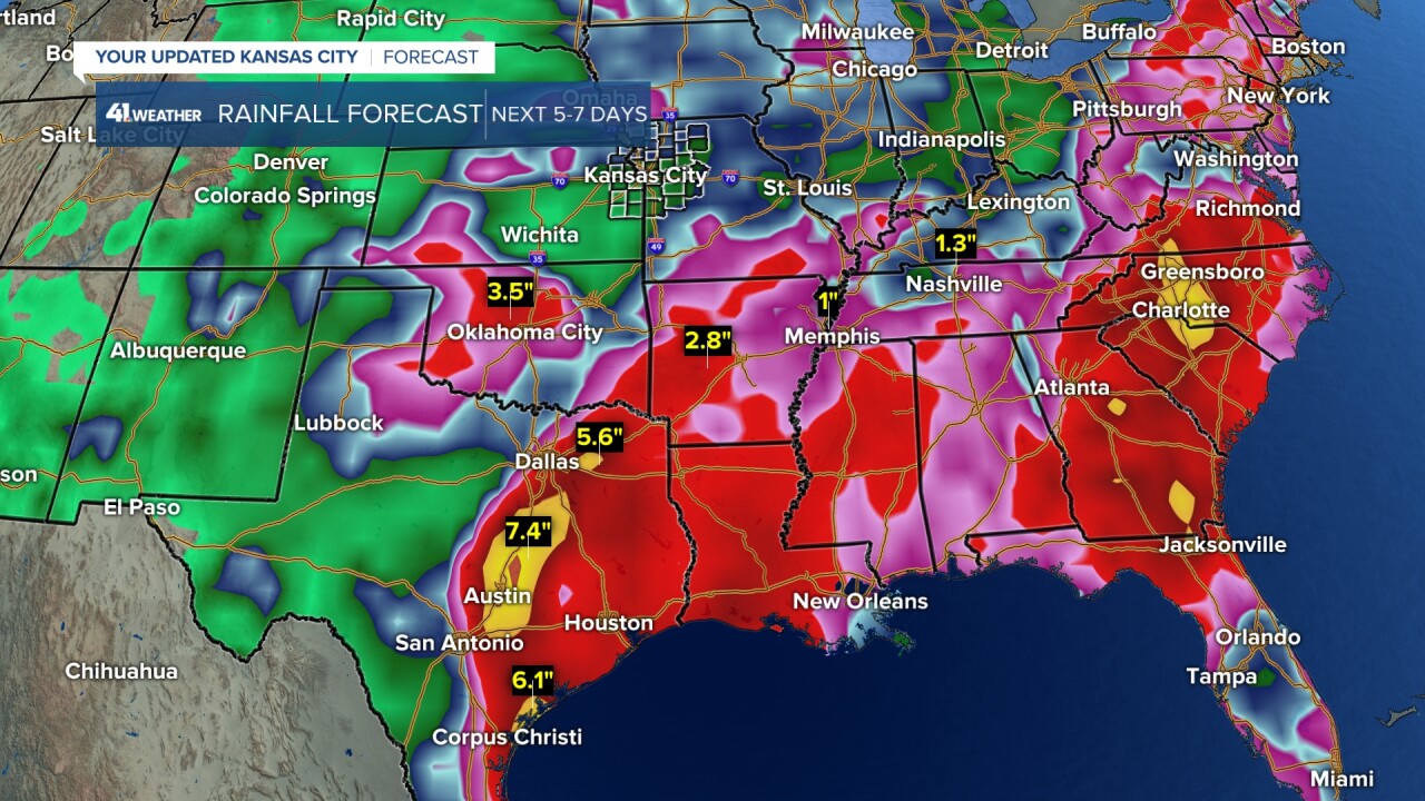
In our region we will see areas receive under .25" and some that see 1"-2" of rain. This data has the least rainfall from south central Kansas to south KC. Again, as I always say, the heaviest rain areas can shift around when it comes to thunderstorms as it is hard to predict where exactly they will set up more than a few hours in advance. But, the take away is that some will see a lot of rain, some will not see much.

WEATHER FORECAST SUMMARY:
The weather looks great today. Thunderstorm chances increase tonight, mainly for northern Missouri and northeast Kansas. Some activity may drift south to I-70. The best chance of showers and thunderstorms in KC is Sunday afternoon and evening.

After Monday it looks dry for seven-10 days. And, highs will reach the 90s by next weekend. So, by day 10, we may need some rain as the topsoil dries out fast this time of year.
Have a great rest of your Fourth of July weekend.
Stay healthy
