Good morning bloggers,
It has been 729 days since our last Tornado Watch in Kansas City. The last watch was on May 28, 2019, the day Linwood, KS experienced the EF-4 tornado. There was a tornado on March 15, 2021, earlier this year, in southern Johnson county, KS, but that was an isolated event that had no Tornado Watch in effect. Tomorrow will make it 730 straight days without a Tornado Watch, but it isn't quite two years, as there was one extra day in 2020 due to it being a leap year. There was a February 29th in 2020, as if we needed an extra day last year of all years. There is a chance a Tornado Watch could be issued for Kansas City tomorrow, but there is a decent chance it is just a Severe Thunderstorm Watch in the morning, and then the risks shift south later in the day. Let's take a look.
The Severe Weather Risk Tonight:

From The Storm Prediction Center (SPC): "Severe thunderstorms will spread across the central Plains during the late afternoon and evening with a threat for large and destructive hail, very damaging winds, and tornadoes. Scattered severe is also expected across the southern High Plains and much of the northeastern US where damaging winds are the primary concern. Environmental conditions appear very favorable for discrete supercells early in the convective cycle ahead of the surface low into northeast CO. With time, numerous supercell structures should grow upscale as they mature along/south of the aforementioned frontal zone. Very large hail will likely be noted with this early activity, and SRH values certainly suggest tornadoes will be a threat until storm mergers lead to a potentially significant MCS downstream over southern NE/northern KS. If an intense MCS does evolve, as seems possible, very damaging winds could be noted along the leading edge of this cluster as it surges east-southeast along the nose of a pronounced Low Level Jet."
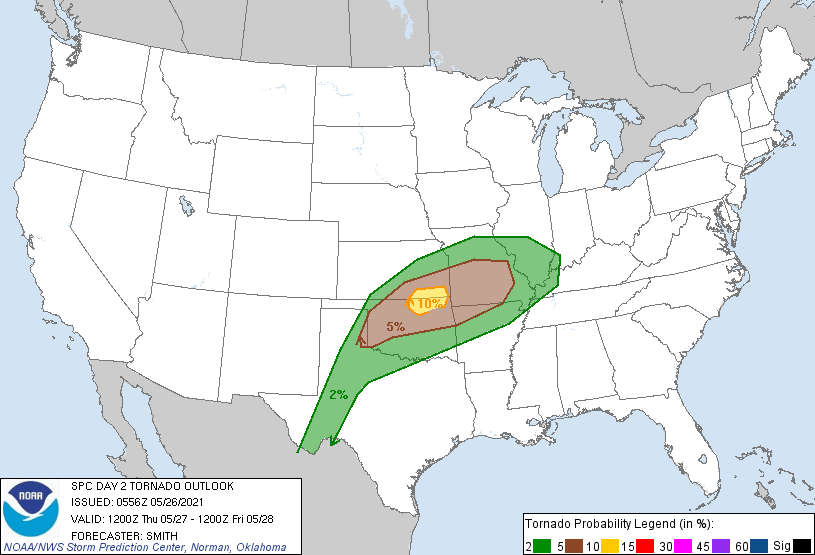
Severe Weather Risk Thursday:

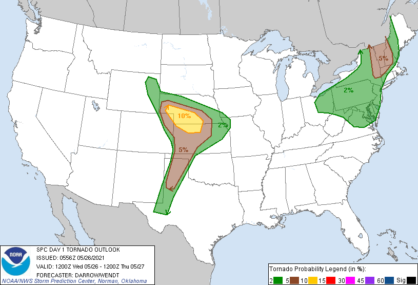
The Tornado Risks From The SPC:

The Tornado Risk today is highest over far northwestern Kansas into southwestern Nebraska. And, then tomorrow the risk shifts south of KC:

For Kansas City, we will be monitoring how this evolves closely. Here is one scenario of many. This is the one I favor at this moment:
By sunset or shortly thereafter, we are expecting severe thunderstorms to break out in the Level 4 out of 5 risk area northwest of Kansas City. We will stay dry with no risk of even a drop of rain before midnight. This map shows the set up at 9 PM:

We will monitor these thunderstorms as they begin forming. Some of our 41 Action News Storm Chasers will be out west chasing this dangerous day. We will check in with their feeds and provide the link for you to follow them on their chase.
After sunset, the thunderstorms will likey organized into and MCS. MCS stands for "Meso-scale Covective System", or an organized area of thunderstorms. These often move east and northeast, and then once they mature, they will turn southeast and head right towards KC.
4 AM Forecast:

As you can see above, the timing on the organization of the MCS is for it to be northwest and still out of our viewing area until 5 or 6 AM.
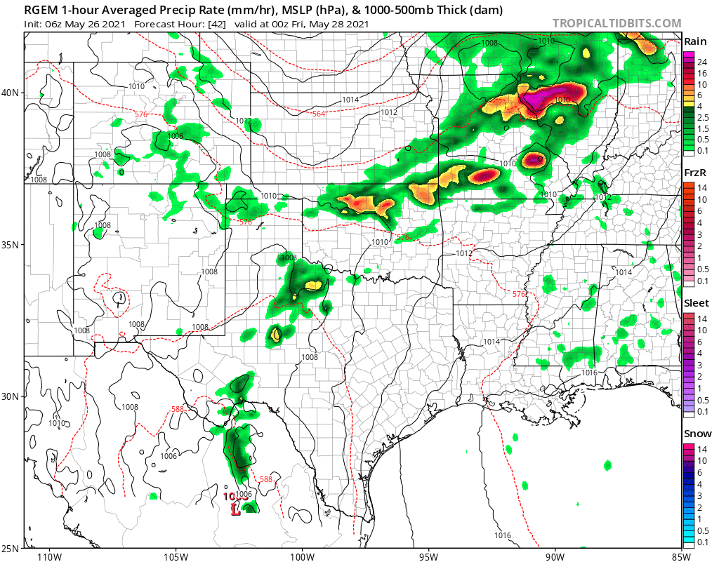
9 AM Thursday:

By 9 AM Thursday, the MCS with the leading edge possibly being severe, will be tracking into KC. If this timing is correct then the chance of afternoon severe thunderstorms is low from I-70 northward tomorrow. Take a look at what is forecast to happen by later in the day:

If this model is at all correct, KC would miss the bulk of the afternoon severe thunderstorm redevelopment. But, is this timing correct? The 4 AM to 9 AM MCS and leading line of severe weather risks may come in a bit faster. It may be two to three hours faster. If it blows through faster, then the atmosphere may have time to recover Thursday afternoon. This would lead to thunderstorms redeveloping near KC at peak heating tomorrow. I lean against this possible scenario, but only slightly. So, we will pay close attention to these developments.
Kansas City Weather Timeline:
So, what does this all mean? We are predicting something that doesn't exist yet. Think about that for a minute. If you ever wonder why it is so difficult for weather forecasters to get it right, then think about the fact that nothing is out there at this moment. We are predicting that thunderstorm will form, organize, and then track our way. In other parts of the nation, they see our thunderstorms forming, and then they just make a prediction on when they will arrive. For KC, more often than almost anywhere else in the world, we have to predict things that aren't there yet.
So, we will be monitoring the area in the level 4 out of 5 risk, and on the air tonight we will make adjustments. Watch closely to our weathercasts from 11 AM to 10 PM and see how our prediction evolves. I lean in the scenario below, and then we will make adjustments as we move through the next few hours.
- Now through midnight: There is no chance of rain or thunderstorms, literally 0% chance. High: 85° and very humid with light winds.
- Midnight - 4 AM: Thunderstorms will be moving our way and possibly entering the viewing area by 4 or 5 AM. There is a chance that this time frame may be adjusted by an hour or two
- 4 AM - 10 AM: Thunderstorms move through with heavy rain, lightning, and possibly some severe weather in the form of damaging winds. The tornado risk is low, but it is not out of the question
- 10 AM - 3 PM: A chance of lingering showers and thunderstorms with heavy rain possible
- 3 PM - 9 PM: Severe Thunderstorms erupt well south of KC, likely on the edge or out of our viewing area. They may form closer to KC if the morning activity is weaker
Thank you for spending a few minutes of your day reading the Gabbing with Gary blog. Have a great day and if any severe weather develops Thursday, stay with 41 Action News, and we'll keep you advised.
Gary


