Good morning bloggers,
The day begins with a rain/snow mix across the KC metro area. This storm has been producing snow, thunderstorms, tornadoes, lightning, and it isn't over yet. This is day 3 of this storm, and there may be a day 4 on Thursday before it moves away.

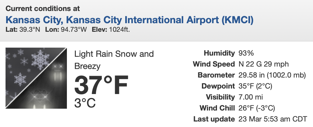
Some spots have rain, but many have snowflakes falling around Kansas City this morning. At KCI Airport, it was 37° with this rain/snow mix and a 29 mph wind gust with low pressure. The pressure is quite low with a 29.58" pressure. So, bundle up this morning.
This same storm just produced a significant tornado in the New Orleans area. It was caught on video and I have seen some fascinating videos being tweeted out and on Youtube. There is even a big cruise ship on the Mississippi River with the tornado in view. Other videos of people taping the tornado around a couple blocks away, which I do not recommend you doing. As of early this morning only one person has been reported killed by this tornado, so as bad as that is, it could have been worse. We are just learning more as the sun rises this morning.
The LRC predicted this storm over 100 days ago. This is a tweet from the NWS in Kansas City, or actually in Pleasant Hill, MO:

As many of you know, we have been showing you the LRC this season at close to 64-65 days. 130 days ago is 65x2. This part of the pattern produced the wet storm and severe weather in November, and then it produced a snowstorm here in KC in mid-January, and severe weather as well. Also in November, on November 13th, this storm produced tornadoes near New York City, and today's risk has shifted to the east coast, and that is also 130 days ago.
The pattern is cycling nearly perfectly, according to the LRC, and unfortunately it looks like Kansas City will have a few of these big severe weather risks this season. We will let you know when in our severe weather special next week.
Speaking of next week, there is a block forming over the northern part of Alaska up near the North Pole, and another one forming over the northern Atlantic Ocean.

The Arctic Oscillation has juts dipped into negative territory for the first time since early February when it had a brief dip. Most of this winter has been in positive territory. And, this is likely one of the reasons why Kansas City never dropped to 0° or lower this winter. It is dipping now, and so is the North Atlantic Oscillation (NAO). And, there is some blocking showing up in the next few days, and it is already showing significant influences on the pattern.
This blocking shows up in the next few days north of Alaska and over Greenland. And, this is causing a strong storm to develop and move into California:

This strong storm is also forecast to move out into the plains next week. Take a look:

If this timing is exactly right, then Kansas City may have a risk late Tuesday night into Wednesday morning with the target again being Louisiana into the Tennessee Valley:

When the AO and NAO dip negative, and this blocking develops, the pattern gets energized. It appears this will happen in the next week. Look at what is forecast to happen in the first few days of April:

What is this? This map shows very heavy snow near KC into southern Iowa with severe weather in the south again. This is a 270 hour forecast from the GFS model. The blocking appears it will have effects on the pattern and we will look deeper into this as we get closer to April.
Eventually these storm systems will be a bit slower and farther north, and this will be when Kansas City will go into more of these severe weather risks. One of the biggest storm systems of the season is forecast to arrive between April 15th and 24th with three or four severe weather risks tracking across the nation.
Weather 20/20 released our hurricane outlook for the season based on the LRC. We are predicting a less active season, and at the same time we see one potential major hurricane to target Florida.
Weather 20/20 Hurricane Forecast Press Release
We are predicting only 2 to 4 landfalling named storm systems in the USA this summer, which is much less than last year's eight landfalling named storms. More on hurricane season later, and read the press release for more information.
Kansas City Weather Time-Line:
- Today: Rain and snow mixed with no accumulation expected. High: 39°
- Tonight: A chance of rain and snow with a dusting possible by morning. Low: 33°
- Thursday: Rain and snow ending early and then mostly cloudy, breezy, and cold. High: 41°
Thank you for spending a few minutes of your day reading the weather blog and sharing in this weather experience. Have a great day.
Gary


