1245 PM WEATHER BLOG UPDATE: The morning, original blog, is below.
Once the Arctic air arrives Saturday it will be here to stay. The average high climbs to 42 by next week. We will be running 20 to 30 degrees below average. The average low warms from 21 to 23. We will be about 20-30 degrees below average on the lows as well.
Wind chill values will be mostly in the -20 to -5 range. This is dangerous cold, especially since we are going to be in it for 7-10 days.

In the morning blog we talked about the zone of snow. This means we will be tracking around 3-4 chances of snow the next 7 days. Our best snow chances the next 5 days are Saturday and Monday. Super Bowl Sunday we could see periods of light snow and flurries with a dusting to 1" possible.
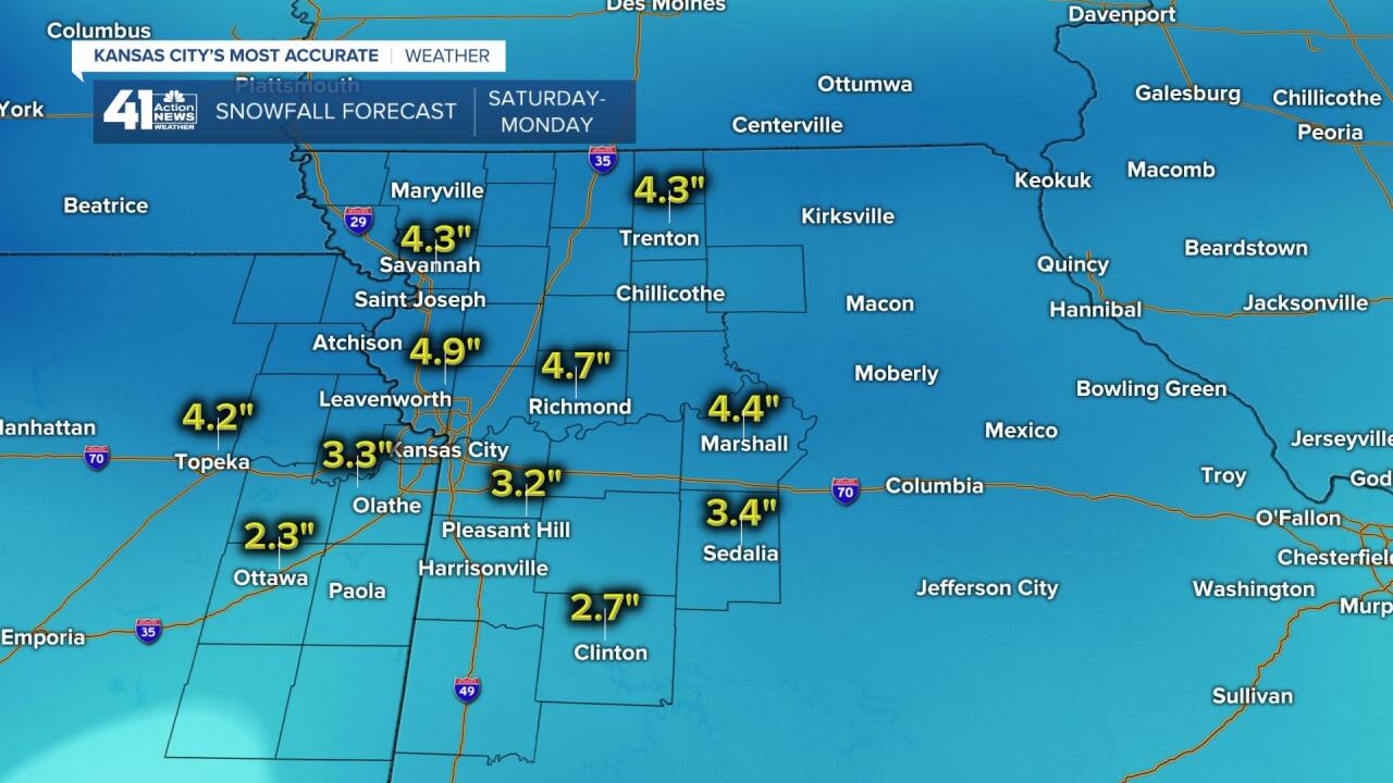
SNOWFALL FORECAST SATURDAY-MONDAY: When you add up the 2-3 chances Saturday-Monday you get the snowfall forecast below.

Our viewing area has a chance to see 3"-5" north to 1"-3" south total through Monday.

Here is the weather timeline for Saturday. The snow should move in 8-10 AM and roads will get slick quick as temperatures drop to the single digits and wind chill values drop to -20 to 0.

------------------------------------------------------------------------------------------------------------------------------
Good Friday bloggers,
The Super Bowl is two days away, hard to believe. Hard to believe the Chiefs are in it for the second straight year. Actually, it is not hard to believe since we have Patrick Mahomes! If Mahomes stays healthy all game, fingers crossed, I would be shocked if the Chiefs lost. My prediction...Chiefs 38-23.
Now lets shift from the Super Bowl to the impending "Super Cold." Arctic air has been sitting in Canada, occasionally making it to I-80 this winter. That is about to change as the pattern is allowing for a massive Arctic air mass to settle south, eventually covering much of the USA during the next 5-7 days.
The Arctic air will not be blasting south, but rather oozing south. As this is happening a series of disturbances will track along the south edge of the Arctic air from the Rockies to central Plains to Midwest. Each one of these disturbances will produce an area of snow, briefly heavy, that lasts 3-6 hours. This is similar to how large complexes of thunderstorms (MCS's, Mesoscale Convective Complexes) form and track during the summer.
We are going to be in this zone of snow from Saturday until the middle of next week. This means every 1-2 days we will have a chance of snow as the Arctic air takes hold of our region.

TODAY: Enjoy the highs in the 40s as we will be on the northern fringe of the milder air. The Arctic air is expanding south.

SATURDAY: Uh oh! We are now in the Arctic air. By afternoon our temperatures may be down in the 10-15 degree range. The day may start in the 20s as one of the snow areas moves by.

This graphic is valid at 9 AM Saturday. It looks like a complex of thunderstorms, but it is snow from southern Kansas to northern Missouri. There are some actual thunderstorms in northern Oklahoma. It is behind this snow area that the true Arctic air will get pushed south. We could see a quick 1"-3".

SUPER BOWL SUNDAY: It will be a good day to watch football as highs struggle to 10! You can see the southern edge of the Arctic air has not advanced much from Saturday. So, we remain in the snow zone. There is a chance of snow Sunday, but details are still up in the air. Dallas is near 60 and Lubbock is near 70.

Officially, after the 0.5" of snow Thursday, we stand at 6.7" for the season. We should be at 11.6" by this time and average for the whole season is 18.6". How much will we add to the seasonal snow total the next 5-7 days? We should see 1"-3" Saturday, but amounts Sunday into next week are up in the air.

We will update this blog early this afternoon after we analyze the new data.
Have a great weekend, stay healthy and GO CHIEFS!


