Good morning bloggers,
It will be a windy and colder day with increasing clouds again today. The Kansas City Royals open up baseball season at The K with the first pitch at 3:10 PM. There may be a few brief showers and it will be a windy day with high temperatures reaching the middle to upper 40s. The weather will improve Friday through the weekend and then we will be analyzing the next severe weather chance. Let's take a look.
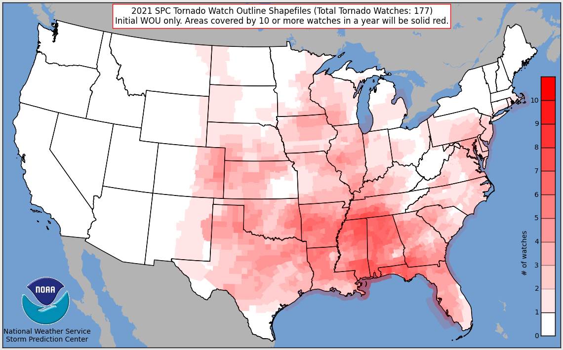
There has been a Tornado Watch drought for three years across Tornado Alley. In fact, there are parts of the KC metro area that has not been under one tornado watch since May 28, 2019, or nearing three straight years. Johnson and Wyandotte counties have not had one of these watches since that big Linwood tornado day. the entire KC metro area was under a tornado watch that day and a powerful EF-4 tornado tracked just south and east of Lawrence, KS and blasted through Linwood before lifting and sparing the KC metro area.
What is a Tornado Watch? A tornado watch is issued when conditions are favorable for severe thunderstorms that may produce hail 1" in diameter or more (size of a quarter or larger), winds of 50 knots or stronger (58 mph), and possibly a tornado. If a tornado is spotted, then the watch gets updated to a tornado warning.
This is likely the record longest stretch ever without a tornado watch.
Here are the Tornado Watches from the past three years:


So, there hasn't been one in Kansas this year, yet. This year's LRC has produced the conditions for tornado watches in Kansas in the first two LRC cycles. Our tornado season often doesn't really get started until around mid to late April. The reason for this is that the storm systems are still so strong that they often push the moisture into the deep south. So, it is usually not warm and humid enough for these risks farther north and west into Tornado Alley (Texas, Oklahoma, Kansas, Missouri, Nebraska, Iowa). Eventually as summer approaches, the humidity and heat gradually shift north and west and then tornado alley lights up in May and June.
If you look closely at all three years, there are a few other areas near by that have also gone nearly three years without a watch. I do not believe we will complete the three years in a row and get all the way to the end of May without multiple tornado watches in the KC metro area. I just see too many chances, even though this next chance may barely miss our area again?
Next week's set-up:

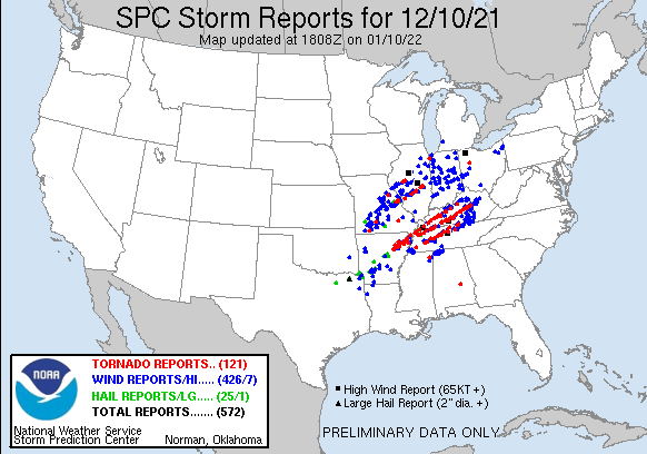
There is another strong storm forecast to move out into the plains states. If this storm slows down just a bit, then the risk will shift to the west and we must monitor this closely Tuesday into Wednesday. As is, on this latest model run, the risk is off to the east again targeting Indiana, Kentucky, south to Louisiana. This is a storm we have predicted using the LRC for four months. Look at where the severe weather occurred in LRC Cycle 2 on December 10, 2021:

If you compare last night's computer model prediction of the set up for next Wednesday night and then look back at what happened December 10th, then it increases my confidence that this model has a good depiction of where the risk may line up next Wednesday. It is almost in the exact same spot.
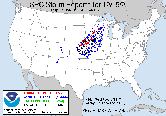
The target appears that it will again be close to that same area that got devastated just 4 months ago when around 90 people were killed by tornadoes. Let's see how the models trend in the next few days. Kansas City's chance will likely by much higher the following week. Look at what happened December 15, 2021:

There was a major severe weather outbreak of high winds and tornadoes in very rare places for December. Tornadoes had never been reported in northern Iowa or Minnesota this late in the year. This part of the pattern will be returning the following week, and this is the part of the pattern I picked out in our severe weather special as one of the main targets for KC this season.
Thank you for sharing in this weather experience and spending a few minutes of your day reading the weather blog. Have a great day. Go Royals!!!!!
Gary


