Happy Hump Day Blog Readers -
It's been a soggy 24 hours. Here at KSHB we have received 2.87'' of rain. But the moisture is still coming thanks to a surface low along the Mexico/Texas line moisture is being continuously pulled into the Plains. As the moisture lifts north it runs into the line of systems we have parading through the upper Great Plains. These lows have lined up to give us a one, two... and three... punch of rain. The first wave arrived yesterday. The second wave is arriving tonight. And the third wave arrives Saturday night.
Here at @KSHB41 we've picked up 2.87'' in the last 24 hours. Our moisture highway remains open for business for the next few days with 2 cold fronts still to come. By the time we get to Monday our rain totals could easily hit 6''.
— ☀️ Cassie Wilson (@CassieKSHB) October 25, 2023
P.S. the Normal October rain total=3.25''@KSHB41 pic.twitter.com/1KjRuxEyIe
Wednesday Night
- Rain and thunderstorms through 8-10 pm
- Then the rain will become more showery in nature
Thursday
- Scattered showers begin to taper by the midday
- We should see a little sun Thursday afternoon
Friday
- Cold front finally passes through between 4-8 am
- More light-moderate rain is possible Friday morning
- Temperatures will start warm Friday but drop rapidly into the low 50s by the afternoon
- A bit of clearing expected Friday night but it will be cold
Then we take a short break while we wait for our next system to roll into focus Saturday night. So if you have big plans with the kids for Halloween events this weekend you'll want to keep an eye on this forecast.
Not the best forecast for Halloween activities coming up this weekend OR for 'Trick or Treating' Tuesday night. I know we were planning on some trunk of treat events this weekend... but this Mama may be changing plans! Who was planning on weekend events vs Halloween?@KSHB41 pic.twitter.com/X4e96Prjfg
— ☀️ Cassie Wilson (@CassieKSHB) October 25, 2023
The interesting thing here to monitor is Sunday morning. This is when the air is cold enough and the rain-snow line is creeping too close for comfort. Saturday night into Sunday morning will be the first big snow of the season here in the Great Plains. But will it drift south into Kansas City? Right now we are leaning on the fact you may look outside Sunday morning and see a flake or grauple or sleet falling and rub your eyes and think wait a second is that snow? Then you'll go get your partner to have them look out the window and by the time they look outside all they will see is rain. That's the scenario I'm leaning with. But I could be wrong... the American model is really eager to make it snow in Kansas City.
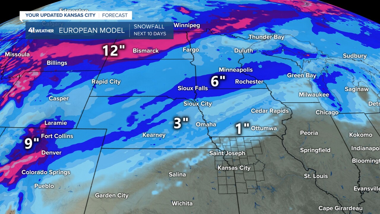
So let's talk about how rare October snow is? Jeff Penner was telling me all about the October Surprise" of 1996 the other day. In general snow in October is rare, we only average 0.3'' here in Kansas City. But on October 22nd, 1996 Jeff said they were tracking a strong upper low that placed the ultimate snow scenario right on top of us. That day, October 22nd, 1996 we saw 6.5'' of snow. The most recently we've seen snow in October was back in 2020.

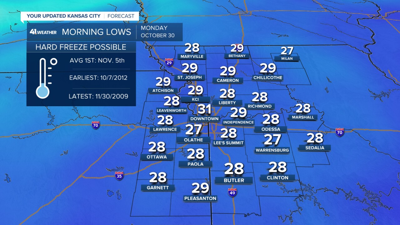
Regardless of snow... it is going to get cold next week. Time to finish your wintertization prep work because Monday morning the first hard freeze of the season is likely. Temperatures are expected to fall into the upper 20's Sunday night into Monday morning with our overnights staying frozen for a few days. Our temperature trend will recover a bit by the first weekend of November but in the meantime we stay chilly. Right now Halloween should be dry but in the 40's with Trick or Treating temps in the 30s.