Good Fourth of July,
We need the rain, but we do not want severe weather and we want the rain and thunderstorms after fireworks this evening. Can we make it three for three? Let's go through this change in our weather.
SEVERE WEATHER RISK FOURTH OF JULY:
First, let's look at the severe weather threat. We are in a level 1 of 5 threat for later tonight with levels 2 and 3 of 5 to our west. This is a sign that thunderstorms will become severe from western Kansas to western Iowa into Minnesota this afternoon with wind, hail and tornadoes all possible.
The thunderstorms will track east and weaken as they approach our area. Our main threat will be strong to severe wind gusts 50-70 mph. 58 mph or higher is officially classified as severe. Some hail is possible as well. 1" diameter or higher is officially classified as severe.
The tornado threat is never zero in these cases, but it is very low for our area.

SEVERE WEATHER RISK JULY 5:
We are on the western edge of the main risk which is a level 2 of 5. The main severe threat tomorrow will likely be southern Kansas to southern Missouri, Illinois and northern sections of Oklahoma and Arkansas. If the front is slower, then we could get in on the northern edge of some severe weather.

Second, let's look at the timing and details.
FOURTH OF JULY (12-5 P.M.):
It will be partly to mostly sunny, hot and humid with highs around 95°. The wind will be south at 5-15 mph, so not much of a breeze.

FOURTH OF JULY (5 P.M.-MIDNIGHT):
It looks dry and warm for fireworks time around here with temperatures dropping to the mid 80s. The wind will be light from the south, so it can get very smoky during the evening with all of the fireworks.
As we enjoy fireworks, thunderstorms will be intensifying and becoming severe from northwest Kansas to central, southeast Nebraska to northwest Iowa to southern Minnesota.

JULY 5 (MIDNIGHT-4 A.M.):
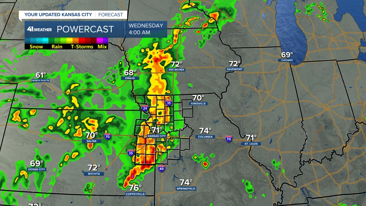
The thunderstorms will be heading this way arriving midnight-2 a.m., perhaps as early as 10-11 p.m. in the northwest corner of Missouri and far northeast Kansas. It will be a close call to get in fireworks before thunderstorms in far northwest Missouri into northeast Kansas.
New data is trending to the thunderstorms weakening as they get to KC, but holding together long enough to bring some rain. As they move in we may see 50-70 mph wind gusts and some hail around 1" in diameter (quarter size).

JULY 5 (4-7 A.M.):
The thunderstorms will mostly have moved through as they weaken and/or the strongest tracking south into southwest Missouri, southeast Kansas, northeast Oklahoma and northwest Arkansas.
We will see lingering showers and thunderstorms with temperatures in the mid 60s to around 70.

JULY 5 (7 A.M.-5 P.M.):
It will be a mostly cloudy day with the chance for a few showers and thunderstorms. Highs will be 80°-85° with a north to northwest wind increasing to 10-20 mph.
You can see the main thunderstorms increasing from southern Wisconsin to eastern Illinois to southern sections of Missouri and Kansas to northern sections of Oklahoma and Arkansas. This is where the main level 2 of 5 severe weather risk is located.

WEDNESDAY NIGHT-THURSDAY:
The humidity will drop and we will see some very nice weather under a partly to mostly cloudy sky. Lows will be around 60° with highs around 80°.
RAINFALL FORECAST TODAY-WEDNESDAY:
Right now it looks like we will see .10"-.50" with some locations seeing .50"-1" rain. You can see 50-80 miles west amounts will be 1"-2" and 50-80 mile east amounts will be near nothing.
This has been happening quite often since April and early May.

Here are rainfall totals during the last 45 days which was May 20 as of July 4. Average rainfall during this period is 7.85". So, even in the wetter areas to the west amounts are 1"-2" below average. But you can see it has been wetter west and drier east. These are rainfall estimates, so your rain gauge may have been reading different.

When you widen the view the rainfall pattern really shows itself. The western plains have received around 1 foot of rain (average around 4"-5") while locations around the Mississippi River have seen mostly 1"-3" of rain (average around 6"-7").
You can see why drought conditions have been improving in the western Plains and worsening across Missouri and Iowa.
We have several chances of rain and thunderstorms the next 10 days. Let's see if we can get one round to buck the trend.

WEATHER FORECAST SUMMARY:
The rain will hold off until after fireworks and we should see at least .10"-.50" of rain. Since the thunderstorms will be weakening any severe weather will be more scattered with the main threat wind gusts to 50-70 mph.
So, we are basically making it 3 for 3, or 2.5 for 3, as we could use more rain and no severe weather.

There is a DRUNK/TEXTING WARNING while driving in effect in memory for all of those who have been injured or killed in drunk/texting while driving accidents. Nathan McDuffie lost his life over 30 years ago in a drunk driving accident.
Please do NOT drink/text while you are driving.
Have a happy and safe Fourth of July.
Stay healthy


