

Good Saturday, bloggers,
We are looking at a series of weather changes this last weekend of March. A storm system tracking out of the southwest USA will run up I-35 tonight as a cold front moves in from the west.

Let's go through the weather changes.
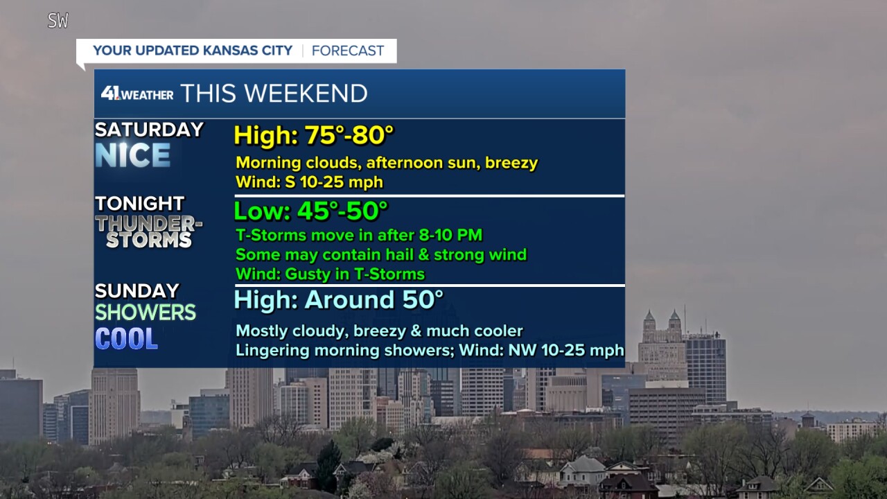
SATURDAY:
A surface low will be located northwest of Salina with a cold front (leading edge of colder air) trailing southwest, a dry line (leading edge of drier air) trailing south and a warm front (leading edge of warmer air) extending northeast from the surface low. This is a "triple point," and any time of year, especially during the spring, it is a signature for potential severe weather.

SATURDAY (5 p.m.):
There are no thunderstorms yet on the triple point as a warm layer at around 10,000 feet is preventing thunderstorms from forming. It will be partly cloudy and warm, with highs well into the 70s. The wind will be south at 10-25 mph.

SATURDAY (8-11 p.m.):
Thunderstorms will form along I-35 to our southwest, and then they will track northeast, arriving in KC after 8-10 p.m. This reduces the severe threat as we will have lost the maximum heat of the day by the time the thunderstorms arrive.

We are in a level 1/2 of 5 risk for mainly hail and strong winds. Hail has to be quarter-sized to be minimum severe, and the wind has to be 58 mph or higher to be classified as severe. So, any severe thunderstorms tonight will most likely be on the low end.

SATURDAY (11 p.m.)-SUNDAY (3 a.m.):
An area of widespread rain and thunderstorms will likely be moving across the area. The severe threat will be greatly reduced.

SUNDAY (3-8 a.m.):
The widespread rain and thunderstorms will exit, followed by scattered rain showers and a temperature drop to the mid-40s. An area of snow will be found across northwest Kansas. It will track northeast into Nebraska as it changes to rain.

SUNDAY (8 a.m.-1 p.m.):
It will be mostly cloudy, breezy and cool with a few rain showers. Highs will be around 50°. So, it will be much cooler if you are headed to the "K".

SUNDAY AFTERNOON:
The cold front will be exiting Missouri as the colder air pours in. Highs will be in the 30s across Iowa and Nebraska.

The severe threat tomorrow shifts east and increases as the storm organizes more and there is deeper Gulf moisture. A level 3 of 5 severe risk is in place from Arkansas to Illinois through eastern Missouri, where there is a higher tornado threat.

RAINFALL FORECAST TODAY-MONDAY MORNING:
There will be a lot of rain from Louisiana to the Great Lakes, 1"-3" with 3"-6" of rain from Louisiana to Alabama.

We could see a widespread 1"-2" of rain mostly tonight. A few locations could see 2"-3" of rain, depending on how thunderstorms set up. But, notice there is a sharp cut off from Emporia to Atchison to Trenton. The rainfall area can still shift 50 miles south or north, so the cut-off of heavy rain could end up just south of KC.

WEEKEND WEATHER SUMMARY:
The main chance of thunderstorms begins 8-10 p.m. tonight and ends 8-10 a.m. Sunday. This is good news for most outdoor events. Now, scattered rain showers could linger into Sunday afternoon.
The Royals will see warm and breezy weather today, then mostly cloudy & much cooler weather Sunday. There may be a few rain showers around during the early part of the game Sunday.

If you are headed to CPKC Stadium this evening for the Current match, the weather looks good as well. But keep an eye to the sky at the end of the match and after.

Have a great weekend.
Stay healthy.
—
