


Happy Halloween bloggers,
This week's weather is full of tricks and treats:
- Trick: An end of the week storm is tricky and right now it looks like it will bring a very good chance of a soaking of rain with some thunderstorms Friday into Saturday
- Treat: It looks like this storm will be long gone by Sunday night football leaving it dry for the tailgating and game experience
- Trick: The wind will pick up later in the week as that storm approaches
- Treat: The wind will be "eerily" calm for trick or treating tonight
The weather looks great for the kids to go trick or treating tonight. Watch out for all of the kids running around in their costumes later today. The wind looks calm and it will be dry and mild. Temperatures will be close to 70 degrees today with it dropping to a still comfortable upper 50s after dark.
The developing weather pattern:
A strong storm system is approaching the western United States. The energy of this storm system will reach the west coast by tomorrow evening as it reorganizes and dives southeast.

There is also a developing tropical storm way down near Central America. It has been a below average tropical season as predicted almost perfectly by the LRC, which I will show later this week. If this storm gets a name, then our prediction of 12 named storms will have been exactly right, a prediction made in March.
This New LRC is still evolving and this next storm has our attention. Look at what is forecast to happen to the energy coming into the west coast by Saturday:
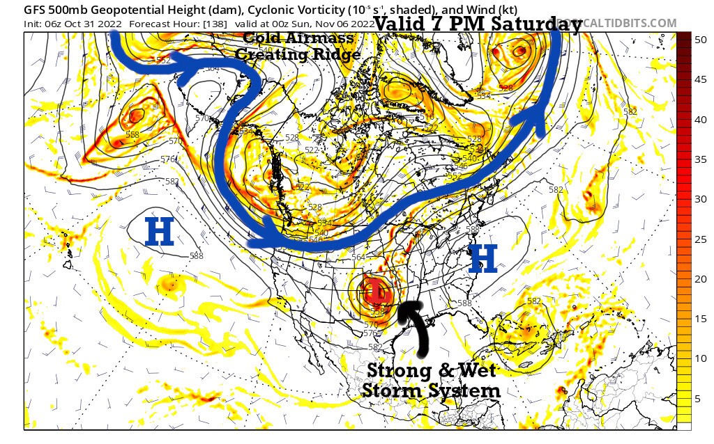
We are looking at the 500 mb flow on these first two maps above. This is the level around 18,000 feet above us. There is a river of air flowing above us and cycling around the world. This cycling pattern is described by the LRC. It is quite organized whereas most meteorologists believe it is all chaos. The New LRC is evolving right before our eyes, and this next storm is going to be fascinating to track this week.

As this storm approaches us later this week something else is brewing. The developing pattern is trying to create a brutally cold air mass over northwest Canada. Temperatures are forecast to drop to 15 degrees below zero by this weekend way up there. The cold front that gets generated will be moving our way early next week.
Between now and next week we get to enjoy a huge warm up into the 70s Tuesday through Thursday. And, then a very good chance of a beneficial rain event by the weekend as some models have 1 to 3 inches of rain. There may be some risk of severe thunderstorms, but right now I am not sure how it will set up. We will learn a lot more by tomorrow.

We just got back from St. Louis after a big night for KSHB-41. We won the biggest award of the night for News Excellence, and I was honored and inducted into the Silver Circle. Here is the video of my acceptance speech:
Gary's induction into the Silver Circle
Thank you for spending a few minutes of your day reading the weather blog and sharing in this weather experience.
Have a great start to the week, and happy Halloween!
Gary
