


KANSAS CITY, Mo. — Good Monday bloggers,
We are tracking two cold fronts this week. These fronts will bring a true start to fall and some rain.
Let's go through this.
TODAY:
It will be another day where highs climb to around 90 with a south breeze 10-20 mph.

TUESDAY:
Here comes cold front No. 1. It will enter the western Plains, interact with the summer heat and humidity and generate a band of rain and thunderstorms, some may be severe. We will see more clouds and wind (S 15-25 mph), so highs will drop a few degrees to the mid and upper 80s. It will still be more like summer than fall.

TUESDAY SEVERE WEATHER THREAT:
There is a level 1 and 2 of 5 threat across western and central sections of Nebraska and Kansas. We have no threat as the thunderstorms will track east and weaken by the time they get here Tuesday night. We will have more on the rain and thunderstorms below.

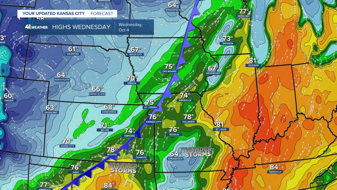
WEDNESDAY:
Cold front No. 1 finally arrives. We will see a lot of clouds and scattered showers and thunderstorms. This will bring our highs down to the 70s, but it will be humid. Highs will be in the 60s across the western Plains, which this is near average for those areas this time of year.
THURSDAY:
Cold front No. 2 appears on our doorstep as cold front No. 1 moves rapidly east to the Tennessee Valley. The clouds, rain, thunderstorms and humidity will be swept east by the first front. So, as the second front arrives it will be sunny with much drier air. This may allow temperatures to approach 80. This second front will not bring any rain or thunderstorms as it moves by due to the lack of humidity.
There is slight chance we see some rain showers Thursday night-early Friday as a small disturbance races southeast behind the front.

FRIDAY:
This is when Fall really begins. Highs will be in the 60s with a northwest breeze 10-20 mph along with a few clouds.

SATURDAY MORNING:
Lows may drop to around 40! Now this is true fall weather and pumpkin patch weather.

SATURDAY AFTERNOON:
It will be a fantastic fall day. Highs will be in the 60s with a light breeze and abundant sunshine.

————————————————————————————————————————————————————
RAINFALL FORECAST:
Now, that we have taken care of the temperatures, let's take care of the biggest issue. How much rain will occur with this fall change? There are many locations running 10"-15" of rain below average since April 1.
TUESDAY 7 p.m.
The line of thunderstorms is approaching. Remember at 7 p.m. it may be severe as it tracks through central sections of Nebraska and Kansas.

TUESDAY MIDNIGHT:
By midnight you can see the line has gone mostly poof! We may see a band of showers and weak thunderstorms.

WEDNESDAY:
The front will be drifting through as a system tracks northeast along the front from the southern Plains. It will create a large area of rain and thunderstorms, some may be severe. We will be on the northwest edge Wednesday afternoon and night into early Thursday. There is a slight chance the western edge shifts a bit west. If this happens, we could see a bonus higher rainfall amount.

THURSDAY:
The thunderstorms will have tracked to mostly east of the Mississippi river as we see the sunshine ahead of the second front.

You can see how we are once again in the minimum with the heaviest west and south of our area. Again, the second area may try to track a bit farther west. Also, the line to our west could hold together a bit longer. These are the ways we see more rain, than we are currently thinking.

As of this moment, the amounts on the new data are paltry, around .25". If we can get the line to the west to hold together a bit longer and/or we get the southern area to come farther west, we may see up to 1". We still need much more, but it is better than nothing. It is the only rain chance the next 7-10 days.

Have a great week and stay healthy.
