


Good Tuesday bloggers,
We are in a calm weather pattern around here, which means some great summer weather heading into Labor Day weekend. This is great news for outdoor activities and the start of college football season. We will have the forecasts below.
Unfortunately, the tropics are not calm, and we are also seeing the return of our old friend the "heat dome." This new heat dome will not be nearly as strong as the last one, and it will not last as long. As a matter of fact, we may have to adjust our dry and hot Labor Day forecast.
————————————————————————————————————————————————————
TROPICS
We are tracking two hurricanes. Franklin and Idalia (pronounced ee-dal-ya).
Franklin is now a Category 3, previously a 4, and is thankfully staying away from land far enough west that it is not directly impacting Bermuda. Idalia is heading north through the eastern Gulf of Mexico and is on the verge of becoming a Category 2 as of 1:30 p.m. Tuesday.

Here is a 30,000-foot look at the tracks of the two hurricanes. Franklin may end up in Greenland this weekend. Combine with another storm, and it ends up producing snow!
Idalia is staying domestic and will impact Florida.

Idalia will make landfall in northern Florida, just east of the panhandle, on Wednesday as a Category 3, perhaps a low-end 4.
This could generate a record storm surge of 10-15 feet, which would be a record for this part of the Florida Gulf Coast.

This is the Powercast map for Wednesday at 9 a.m.

————————————————————————————————————————————————————
HEAT DOME
TODAY:
As we look at the upper-level flow, about 18,000 feet, the heat dome is located over the southwest U.S. This puts us in north flow aloft, which keeps temperatures at or below average.
Notice the little low tracking south across Oklahoma. This brought scattered showers and thunderstorms to western and central sections of Kansas and Nebraska Monday.
Remember this little low.

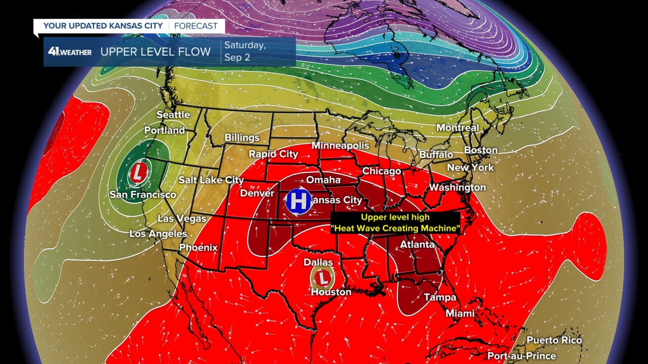
SATURDAY:
Saturday will see the heat dome expand and track east into the middle of the country; yes, over KC.
This dome is not as strong as the last one. The humidity is also not as high as the last one, and this will likely not last as long as the last one.
Notice the little low in southeast Texas. That is the same low as the map above.
LABOR DAY:
Here is the reason for the potential tweak to the Labor Day forecast.
The little low has returned to our area from the south on the western side of the heat dome that is moving east. If the little low is there, it will bring areas of clouds and scattered showers and thunderstorms.
This is not set yet as some data has the low coming in Tuesday, and some have it much weaker.

DAY-BY-DAY FORECAST THROUGH LABOR DAY
WEDNESDAY-THURSDAY:
These will be very similar and very nice weather days. Highs will be 80-85 with lows 60-65 under a sunny sky with low humidity during the afternoon. The wind will be east 5-15 mph Wednesday and southeast 5-15 mph Thursday.
The Great Lakes will have a fall feel with highs in the 60s and lows in the 40s!


FRIDAY:
This will be a sunny day with the start of a warming trend. Highs will creep back up to 85-90 with a southeast wind of 10-15 mph. It will still be a nice summer day.

SATURDAY-SUNDAY:
These will be the hottest days as the dome moves overhead. Highs will be 90-95 with a bit of an increase in humidity.
A south breeze at 10-20 mph may help a bit. We do not expect heat index values at 120-130. The heat index will be more like 100-105, which is still very hot, but at least not like the last time.


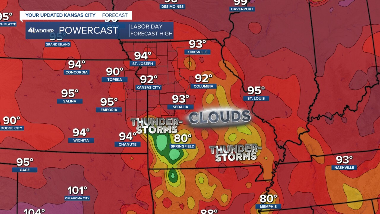
LABOR DAY:
Right now, we are going for a high in the low 90s with a 20% chance of an isolated shower or thunderstorm.

As we zoom in, you can see highs around 80 where there are more clouds, showers and thunderstorms. We will see how this evolves through the week as the forecast is 100% dependent on the actions of the little low.
COLLEGE FOOTBALL FORECASTS
The weather looks great for all the games. It will be a bit hot in Manhattan, Kansas.


Have a great week ahead.
Stay healthy.
—
