

Good Tuesday bloggers,
A severe thunderstorm watch is now in effect for the entire area until midnight.
60 mph winds and quarter sized hail are the main threats.
Flash flooding is a threat as well; remember, "Turn around, don't drown."

Our heat and high humidity are now giving way to thunderstorms as a cold front approaches from the northwest.
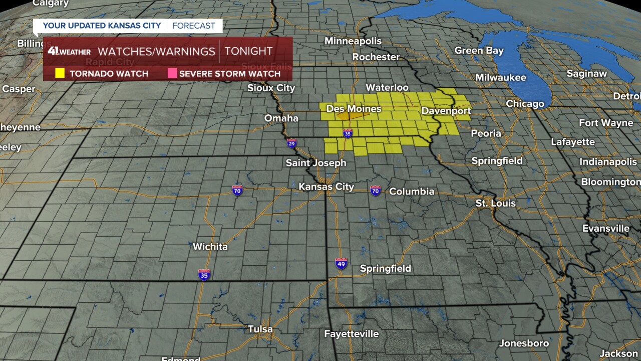
As of 4 p.m., there is a tornado watch in effect until 9 p.m. for far northern Missouri and Iowa.
There is a flood watch for all locations tonight into Wednesday morning.
This is the main threat in KC — flash flooding as the ground is pretty saturated and some thunderstorms may have rainfall rates of 2 to 3 inches per hour.
The light green are the river and stream flood warnings.
This rain will not be helping the Missouri River flooding in any way.

Let's go through all of this.
Tonight:
Thunderstorms were forming on a cold front around 4 p.m.
Once they form, they track northeast at 45 mph while the line sags southeast at 15-20 mph.

So, by 11 p.m., you can see quite a line of thunderstorms from Oklahoma to Michigan.
The most organized thunderstorms are from northeast Missouri to northern Illinois.
This is where widespread damaging wind, flash flood threat and a possible tornado are most likely.
The thunderstorms here will have a damaging wind, hail and flash flooding threat, but they will be a bit weaker and less organized.

Wednesday morning:
There is a chance for lingering showers and thunderstorms as we see new rain and thunderstorms forming in western Kansas.

Wednesday afternoon:
This is when we have the best chance of rain and thunderstorms as a disturbance comes in from the southwest.
These would not be severe, but flash flooding is a threat as these thunderstorms are north of the front. Highs tomorrow will be 80-85 degrees.

Wednesday night:
We will be tracking several rounds of rain and thunderstorms.
The severe threat is low, but the flash flooding threat is high.

Fourth of July morning:
Any thunderstorms will end early, so neighborhood parades may end up being OK.
Lows will be around 70, warming in to the 70s by 9 a.m.

Fourth of July afternoon/evening:
OK, will we get to see unnatural fireworks or natural ones?
A cold front will be approaching and there is a slight trend where scattered thunderstorms form on this front from 3-6 p.m. in our area. Some would be severe.

But, the fireworks displays are in the 9-10 p.m. range.
And again, it is a slight trend, but it looks like the front and thunderstorms will really get their act together southeast of KC between 6 p.m. and 9 p.m.
This would mean it is a go for unnatural fireworks. We will see what this looks like tomorrow.

Weather forecast story:
So, the best chance of thunderstorms in KC is 7 p.m. to 2 a.m. tonight; Wednesday afternoon and night; early Thursday; and 3 to 7 p.m. Thursday.
Total rainfall for most locations will be 1 to 2 inches.
There will be some locations that see 2 to 6 inches of rain. Those locations are hard to pick out in advance with a thunderstorm situation.
The good news is that Friday and Saturday look very nice with highs in the 80s and lows in the low 60s. The humidity will be much lower as well.
There is an increasing chance of thunderstorms Sunday.

Have a great rest of your week and Fourth of July holiday weekend.
Please do NOT drink/text and drive.
—
