


KANSAS CITY, Mo. — Good Thursday bloggers,
We are in for another very cold night before a warming trend begins Friday.
This has been quite a cold stretch. Look at the low temperatures this morning in Nebraska. These are not wind chill values! -33° in Valentine, -32° at Broken Bow to -25° at North Platte. We were -10° and it was -20° at K-State in Manhattan, Kansas, which seems warm compared to Nebraska.

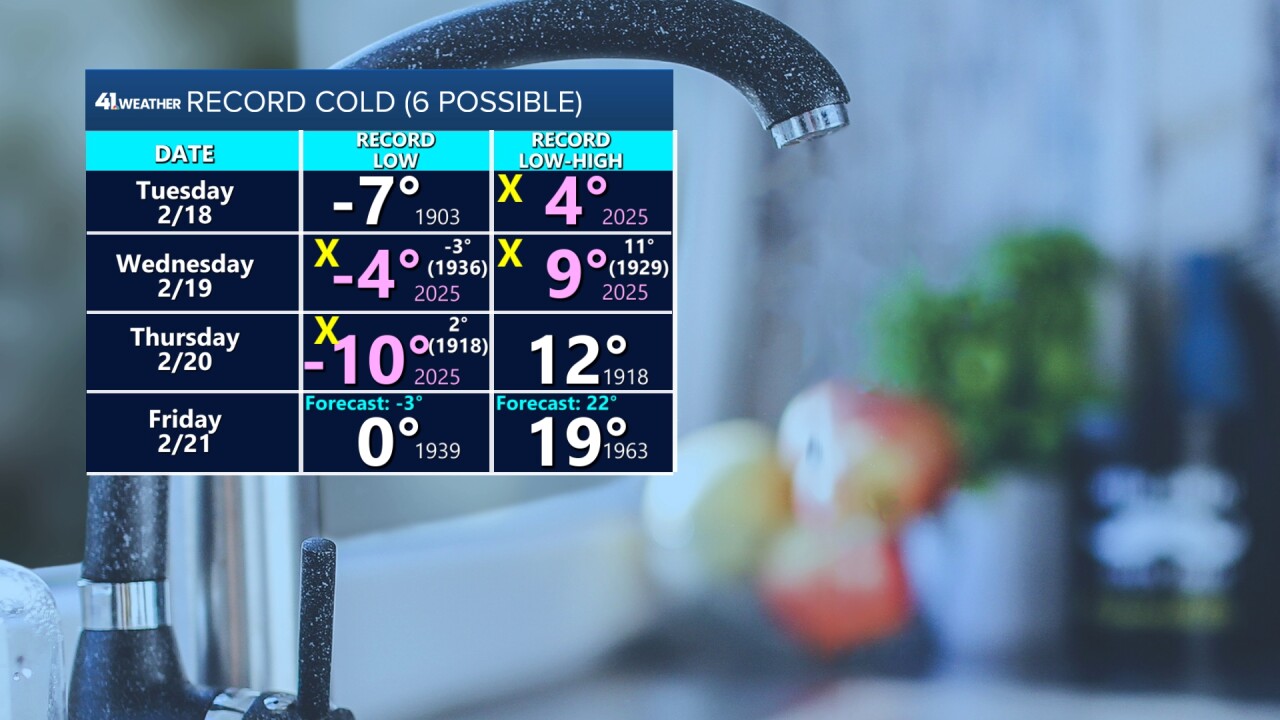
We have broken four records and could break one or two more.
The temperatures in pink are the new record. We broke record-cold high temperatures on Tuesday and Wednesday. We broke record-cold low temperatures on Wednesday and Thursday. We will likely break a record low tonight if it drops to -1°. We are forecasting -3°. We could break the record-cold high Friday if clouds keep us to 19° or lower.
The cold has brought a lot of ice floes to the Missouri and Kansas rivers.

TONIGHT-FRIDAY:
It will not be as cold tonight as it could be due to clouds. Clouds act like a blanket at night. The clouds are coming from a small system in the Rockies and it may bring flurries and scattered snow showers Friday. A few locations could get dusted white. Otherwise, we do not expect accumulation.

LOWS FRIDAY:
Clouds will help a tad.

HIGHS FRIDAY:
Clouds during the day keep it cooler. And again, we may see scattered snow showers.

SATURDAY:
Lows and highs will be 10-15 degrees warmer than Friday with abundant sunshine.


SUNDAY-MONDAY:
Now the warming trend takes off. We are going 47° and 58° respectively. If the snowpack we are in the middle of melts faster, 60° will be easy on Monday.


Now, let's take a quick peek into early March by looking at the upper-level flow.
FEBRUARY 21-28:
We will have a flatter, west-northwest flow. This means one or two small systems and milder flow from the Pacific Ocean. One of the systems is timed for next Wednesday-Thursday. It could bring a little bit of rain.

MARCH 1-3:
We will see the flow turn more from the northwest. This means a shot of colder air, but no big storm system.

MARCH 4-10:
The pattern will become more active. The next chance to see a bigger storm will be around March 5 as we see a big trough in the western USA. This bigger storm could bring rain and/or snow. We are not done with winter yet.

Have a great weekend.
Stay healthy.
