


Good Monday bloggers,
We are tracking a return to the Canadian wildfire smoke, the chance for a heat wave and the chance of thunderstorms. How will all of this affect the holiday weekend?
Sunday our sky was crystal clear and blue. Today will be clear as well, but hazy. A storm system in the Great Lakes is bringing the smoke south from Canada and was responsible for our red sunrise.
You can see the circulation around the west side of the storm is pinwheeling the smoke south and west back to our region. Fortunately, it will be above 10,000 feet and not cause pollution at the surface like it did last week.

After today, we are tracking the chance of thunderstorms, a potential heat wave and the Fourth of July holiday weekend weather.

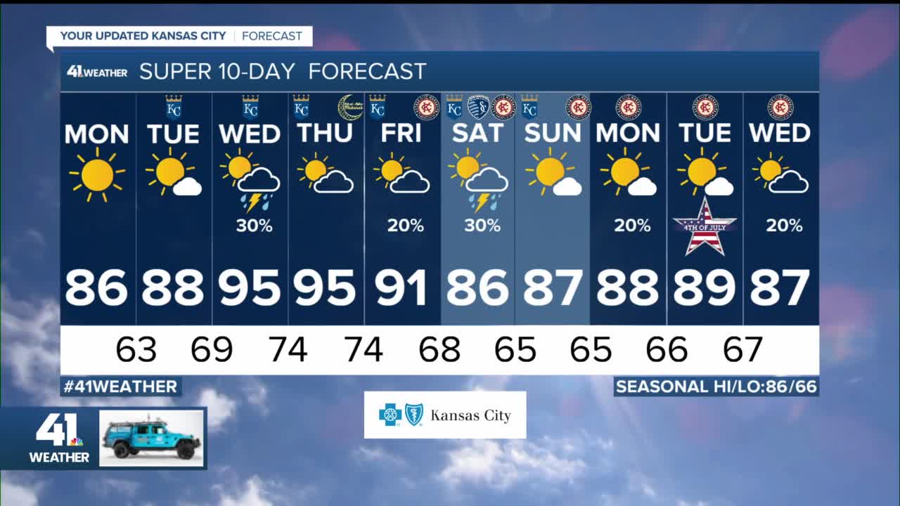
Let's go day-by-day through Saturday, the start of the holiday weekend.
TODAY:
We will see more great weather, like Sunday, as highs reach the mid 80s. The humidity will stay low, the wind will be a bit less than Sunday. The wind will be Northwest at 10-20 mph. It will be much more hazy as the smoke is in the air.
A heat wave will intensify in Texas as Dallas will see highs make a run at 110°. Thunderstorm areas and clusters can run along the northern edge of the heat. So, as the heat builds north, could that increase our chance of thunderstorms?

TUESDAY:
We will see highs climb to the upper 80s with a bit more humidity. We will see more clouds as well with the chance of a sprinkle. The wind will be light from the east and southeast. The heat stays in Texas and begins to affect Oklahoma. This will put the zone of thunderstorm development farther north into Kansas.

TUESDAY NIGHT-WEDNESDAY MORNING:
A cluster of thunderstorms is likely. Now, where will it track? Will it track south or north of KC like has been mostly happening this season? This data has the main rain and thunderstorms tracking south. Now, this is not set yet. Let's see what it looks like tomorrow. The good news is that even if it misses KC, all locations across Kansas and Missouri need rain. So, wherever the thunderstorms track is good.

WEDNESDAY AFTERNOON:
Any rain and thunderstorms will end Wednesday morning. This will be followed by the heat and humidity. We are going for a high of 95°. But, if the thunderstorms linger longer into the morning we will see highs in the 80s to low 90s.

THURSDAY:
This looks like the hottest day of the week. We are going for a high of 95° again. But, if there are no morning thunderstorms then we could be closer to 100°. Conversely, if there are more morning thunderstorms and/or that stalled front is farther south, then we will see highs under 95°.

FRIDAY:
The stalled front to the north will turn into a cold front and sag south. This will increase our chance of rain and thunderstorms Friday into Saturday. We are going for a high of 91° Friday. We will be 95° or higher if the front is slower. We will see highs in the 80s if the front is faster and/or there are more thunderstorms.

FRIDAY NIGHT-SATURDAY:
This is starting to look like our best chance of thunderstorms the next seven days and our best chance of rain for the holiday weekend.
This front should exit later Saturday paving the way for some nice Fourth of July weekend weather Sunday-Tuesday. Highs will be in the 80s with lows in the 60s. We could see a few thunderstorms on Tuesday, July 4.

So, the only way we see a heat wave is if it is 95° or higher Wednesday through Friday. Remember, a heat wave in our area requires highs to reach 95° or higher three straight days. The heat wave chance is on shaky ground as there are many weather features to interrupt it. Missing the heat wave is a good thing, missing the rain is a bad thing. We will look at this again Tuesday.
Have a great week and stay healthy.
