KANSAS CITY, Mo. — Good Wednesday, bloggers —
In order to make the winter forecast, we use the LRC, Lezak's Recurring Cycle. If you have been a long-time reader of this blog, you know all about it.
Gary Lezak retired from TV two years ago! Time is flying. He developed this theory and it was named by you, the bloggers.
In case you do not know what the LRC is all about or forgot, here is a refresher course.
A unique pattern sets up in October and November and then begins cycling through the winter, the next spring and summer. So, it is crucial to observe and detail what the storm systems and non-storm systems are doing and how they act during October and November, the crucial months when the new LRC is forming.
The LRC is the centerpiece of a large atmospheric puzzle. La Niña, El Niño, Arctic Oscillation (AO) and North Atlantic Oscillation (NAO) are among other factors that influence the LRC.

So, what have we observed this season?
Around 70% of the weather pattern featured a storm track that took storm systems from the northern Pacific Ocean to the Southwest, then northeast across the Plains and Midwest, exiting the U.S. through northern New England.

This is an active weather pattern in our region as the storm systems dropping into the Southwest are able to pick up Gulf of Mexico moisture before they track through here.
In other words, instead of precipitation forming from here eastward, it forms much farther west, putting Kansas City in areas of more mature and widespread precipitation.
This is rainfall/melted snow between Oct. 20 and Dec. 4. You can see quite a swath of blue and purple from west Texas to the Great Lakes.
Amarillo, Texas, had its wettest November ever by over around 1". This swath of precipitation fits in well with the storm track observed.

Let's put some numbers to the colors and zoom in. These amounts are astounding when you keep in mind that the average rainfall between Oct. 20 to Dec. 4 in KC is around 3".
The average rainfall from Dodge City, Kansas, to Amarillo, Texas, is about 1". So, you are looking at rainfall 200% to 400% of average.
Oklahoma, Arkansas and part of southern Missouri have seen rainfall 400% to 600% of average.

This is rainfall in KC since July 5. We saw 1.76" more rain between Oct. 24 and Dec. 4 than we did between July 5 and Oct. 23.
That is truly incredible when you realize that we averaged 14.60" of rain between July 5 and Oct. 23, and only 2.89" between Oct. 24 and Dec. 4.

That rainfall was about as welcomed as you can get as most locations across the region were in the middle of a rapidly worsening drought.
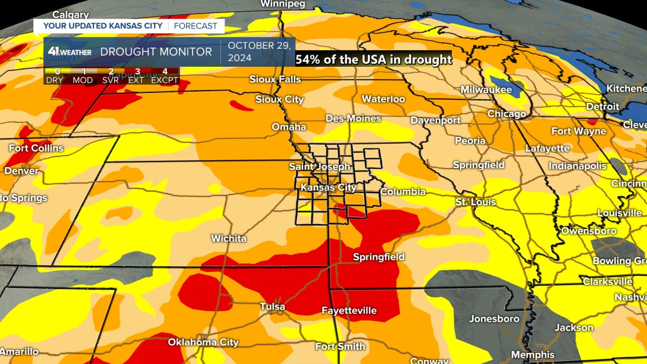
This was the drought monitor on Oct. 29, 2024. 54% of the country was in drought, and we were in a severe to extreme drought.
This is levels 3 and 4 of 5.

Here is the latest drought monitor from Nov. 26, 2024, just 28 days later.
It is incredible how much of the drought in our region has been eliminated. Our drought has been almost eliminated, dropping to moderate.
The U.S. was 41% in drought, down from 54% just a month prior! Note that the yellow is "abnormally dry" and is not counted in the drought percentage.

What does this mean for the winter? How much snow will we see? How could it affect the 2025 wheat, corn and soybean growing seasons?
Join us at 6:30 p.m. Wednesday on KSHB 41 for the answer to those questions.
We also explore the science behind winter weather, from frigid arctic air outbreaks to the impact of climate change on chocolate production.
We'll discuss the recent surge in Northern Lights sightings and share tips for winter weather preparedness, too.


